About ESA
The European Space Agency (ESA) is Europe’s gateway to space. Its mission is to shape the development of Europe’s space capability and ensure that investment in space continues to deliver benefits to the citizens of Europe and the world.
Highlights


Latest


Space in Member States
Find out more about space activities in our 23 Member States, and understand how ESA works together with their national agencies, institutions and organisations.
 Germany
 Austria
 Belgium
 Denmark
 Spain
Spain
 Estonia
 Finland
 France
 Greece
 Hungary
 Ireland
 Italy
Italy
 Luxembourg
 Norway
 The Netherlands
 Poland
 Portugal
 Czechia
 Romania
 United Kingdom
 Slovenia
 Sweden
 Switzerland
Science & Exploration
Exploring our Solar System and unlocking the secrets of the Universe
Go to topicAstronauts


Latest


Enabling & Support
Making space accessible and developing the technologies for the future
Go to topicLatest


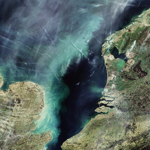
Denmark, Contrails - MERIS - 1 June 2003
This MERIS (MEdium Resolution Imaging Spectrometer) shows much of northeastern Europe, including areas of Germany, Sweden, Poland and Denmark.
The interesting features on this image are the elongate clouds around and to the east of Denmark, particularly visible over the sea. These are in fact condensation trails formed by water vapour from aeroplanes. This part of the world being very busy for air travel as can be seen by the number of contrails, it is thought that these contrails can form into high altitude cirrus clouds, which could contribute towards global warming.
Work within ESA's Data User Element (DUE) is currently looking into condensation trails and any effects they could be having on climate change.
Technical Information:
Instrument: MEdium Resolution Imaging Spectrometer (MERIS)
Dates of Acquisition: 1 st June 2003
Orbit number: 06546
Instrument features: Reduced Resolution image (1200 - metre resolution)
Coordinates:
NE Lat/Long: N 57.72 / 29.25 E
NW Lat/Long: N 61.09 / 9.74 E
SW Lat/Long: N 49.71 / 6.27 E
SE Lat/Long: N 46.92 / 21.44 E