About ESA
The European Space Agency (ESA) is Europe’s gateway to space. Its mission is to shape the development of Europe’s space capability and ensure that investment in space continues to deliver benefits to the citizens of Europe and the world.
Highlights


Latest


Space in Member States
Find out more about space activities in our 23 Member States, and understand how ESA works together with their national agencies, institutions and organisations.
 Germany
 Austria
 Belgium
 Denmark
 Spain
Spain
 Estonia
 Finland
 France
 Greece
 Hungary
 Ireland
 Italy
Italy
 Luxembourg
 Norway
 The Netherlands
 Poland
 Portugal
 Czechia
 Romania
 United Kingdom
 Slovenia
 Sweden
 Switzerland
Science & Exploration
Exploring our Solar System and unlocking the secrets of the Universe
Go to topicAstronauts


Latest


Enabling & Support
Making space accessible and developing the technologies for the future
Go to topicLatest


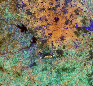
Gujarat, India - MERIS - 17 December 2003
This MERIS (MEdium Resolution Imaging Spectrometer) image is of Gujarat in north-eastern India. The State has a population of over 50 million, with its capital Gandhinagar and largest city Ahmadabad visible in grey tones in the north east of the province.
Much of the state is a fertile plain, healthy vegetation is shown as red in the image, which is cut by several rivers. Sedimentation from some of these rivers in the Gulf of Kachchh, to the north, and the Gulf of Khambhat, can be clearly scene in green shades in the sea. The sudden change from light blue to dark blue in the image is likely to be caused by a relatively sudden change in ocean depth.
To the north the brighter shades are mudflats, which border the Thar Desert at the top of the image.
In the south east corner of the image is the city of Bombay (or Mumbai) with a population of nearly 12 million it is one of the largest and most congested cities in the world. The city used to be made up of 7 islands, though through dredging and land reclamation the islands have been linked to form one, Bombay Island.
Technical Information:
Instrument: MEdium Resolution Imaging Spectrometer (MERIS)
Dates of Acquisition: 17 th December 2003
Orbit number: 09392
Instrument features: Full Resolution image (300 - metre resolution)
Coordinates:
NE Lat/Long: N 23.81 / E 74.49
NW Lat/Long: N 25.04 / E 68.90
SW Lat/Long: N 19.20 / E 67.54
SE Lat/Long: N 18.01 / E 72.92