About ESA
The European Space Agency (ESA) is Europe’s gateway to space. Its mission is to shape the development of Europe’s space capability and ensure that investment in space continues to deliver benefits to the citizens of Europe and the world.
Highlights


Latest


Space in Member States
Find out more about space activities in our 23 Member States, and understand how ESA works together with their national agencies, institutions and organisations.
 Germany
 Austria
 Belgium
 Denmark
 Spain
Spain
 Estonia
 Finland
 France
 Greece
 Hungary
 Ireland
 Italy
Italy
 Luxembourg
 Norway
 The Netherlands
 Poland
 Portugal
 Czechia
 Romania
 United Kingdom
 Slovenia
 Sweden
 Switzerland
Science & Exploration
Exploring our Solar System and unlocking the secrets of the Universe
Go to topicAstronauts


Latest


Enabling & Support
Making space accessible and developing the technologies for the future
Go to topicLatest


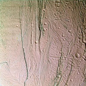
Narrow-angle camera view of surface of Enceladus
The southern polar terrain of Enceladus strewn with ice boulders in this view, one of the highest resolution images obtained so far by NASA/ESA/ASI Cassini of any world.
Some smearing of the image due to spacecraft motion is apparent in this scene, which was acquired as Enceladus raced past Cassini's field of view near the time of closest approach. At the time, the imaging cameras were pointed close to the moon's limb (edge), rather than directly below the spacecraft. This allowed for less motion blur than would have been apparent had the cameras pointed straight down. So the terrain imaged here was actually at a distance of 319 kilometres.
This image was taken during Cassini's close fly-by of 14 July 2005, from a distance of approximately 208 kilometres above Enceladus. Resolution in the image is about 4 metres per pixel. The image has been contrast enhanced to improve the visibility of surface.