About ESA
The European Space Agency (ESA) is Europe’s gateway to space. Its mission is to shape the development of Europe’s space capability and ensure that investment in space continues to deliver benefits to the citizens of Europe and the world.
Highlights


Latest


Space in Member States
Find out more about space activities in our 23 Member States, and understand how ESA works together with their national agencies, institutions and organisations.
 Germany
 Austria
 Belgium
 Denmark
 Spain
Spain
 Estonia
 Finland
 France
 Greece
 Hungary
 Ireland
 Italy
Italy
 Luxembourg
 Norway
 The Netherlands
 Poland
 Portugal
 Czechia
 Romania
 United Kingdom
 Slovenia
 Sweden
 Switzerland
Science & Exploration
Exploring our Solar System and unlocking the secrets of the Universe
Go to topicAstronauts


Latest


Enabling & Support
Making space accessible and developing the technologies for the future
Go to topicLatest


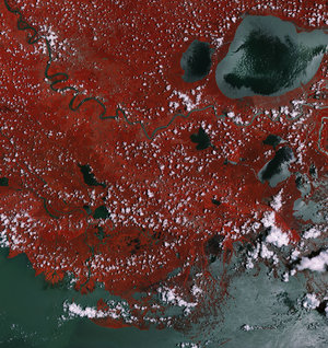
Envisat image of US Mississippi
The Mississippi River Delta empties sediment into the Gulf of Mexico in this Envisat image acquired on 6 February 2007 with its Medium Resolution Imaging Spectrometer (MERIS) instrument. Over the last several decades, however, the delta’s sediment load has been drastically reduced by natural and man-made factors, causing extensive land loss, which is mostly wetland loss. If this process continues at the current pace, Louisiana could be left with less than 5 percent of the wetlands it had in the 1930s. As wetlands erode, parts of Louisiana, such as New Orleans (the light yellow crescent just below the inland lake, Lake Pontchartrain), become completely exposed to storms coming in from the gulf.