About ESA
The European Space Agency (ESA) is Europe’s gateway to space. Its mission is to shape the development of Europe’s space capability and ensure that investment in space continues to deliver benefits to the citizens of Europe and the world.
Highlights


Latest


Space in Member States
Find out more about space activities in our 23 Member States, and understand how ESA works together with their national agencies, institutions and organisations.
 Germany
 Austria
 Belgium
 Denmark
 Spain
Spain
 Estonia
 Finland
 France
 Greece
 Hungary
 Ireland
 Italy
Italy
 Luxembourg
 Norway
 The Netherlands
 Poland
 Portugal
 Czechia
 Romania
 United Kingdom
 Slovenia
 Sweden
 Switzerland
Science & Exploration
Exploring our Solar System and unlocking the secrets of the Universe
Go to topicAstronauts


Latest


Enabling & Support
Making space accessible and developing the technologies for the future
Go to topicLatest


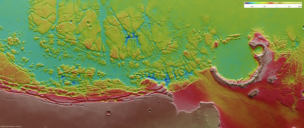
Olympus Mons, ortho-image
This is a mosaic of Olympus Mons, the highest volcano on Mars, which towers 26 km above the surrounding plains. The image covers an area of approximately 600 000 sq km and is colour-coded according to height based on data from the Digital Terrain Model (DTM). The High Resolution Stereo Camera (HRSC) on board ESA’s Mars Express orbiter imaged the region over 18 orbits.
This image is an ortho-image mosaic, where the projecting rays are perpendicular to the plane of projection. This corrects any deformations introduced by an imaging camera. Such an image can be fitted directly on to a map.
From the observations, 16 HRSC orbit strips, with around 35 Gigabytes of data were used to generate a Digital Terrain Model (DTM) mosaic and an ortho-image mosaic. The DTM mosaic has a resolution of 150 m/pixel. The resolution of individual nadir images (taken by pointing the camera vertically down to the surface) is in the range of 12 to 40 m/pixel. Individual terrain models with a resolution of up to 50 m were derived for every HRSC image strip.
The high-resolution DTMs and ortho-images are derived through a complex process. Matching surface features were used to 'stitch' the images strips together, and complex geometrical calculations were used to produce the 3D coordinates of all measured points in the area.