About ESA
The European Space Agency (ESA) is Europe’s gateway to space. Its mission is to shape the development of Europe’s space capability and ensure that investment in space continues to deliver benefits to the citizens of Europe and the world.
Highlights


Latest


Space in Member States
Find out more about space activities in our 23 Member States, and understand how ESA works together with their national agencies, institutions and organisations.
 Germany
 Austria
 Belgium
 Denmark
 Spain
Spain
 Estonia
 Finland
 France
 Greece
 Hungary
 Ireland
 Italy
Italy
 Luxembourg
 Norway
 The Netherlands
 Poland
 Portugal
 Czechia
 Romania
 United Kingdom
 Slovenia
 Sweden
 Switzerland
Science & Exploration
Exploring our Solar System and unlocking the secrets of the Universe
Go to topicAstronauts


Latest


Enabling & Support
Making space accessible and developing the technologies for the future
Go to topicLatest


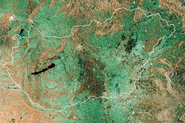
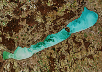
Lake Neusiedl, Austria
Lake Neusiedl, straddling the Austrian–Hungarian border, is featured in this satellite image, acquired by SPOT-4 on 9 October 2006. The largest steppe lake in Central Europe, Neusiedl covers an area around 315 sq km, with 240 sq km situated in Austria and 75 sq km in Hungary (bottom).
The Leitha Mountain range, called 'Leithaberg' by locals, is visible in green northwest of the lake. The famous Danube River, one of Europe's main traffic arteries, is visible running across the top of the image. An aircraft condensation trail, or 'contrail', is visible in white stretching across the image centre. A shadow of the contrail is visible along the top of the image.
SPOT-4 is supported by ESA as a 'Third Party Mission', which means ESA utilises its multi-mission European ground infrastructure and expertise to acquire, process and distribute data from the satellite to its wide user community.