About ESA
The European Space Agency (ESA) is Europe’s gateway to space. Its mission is to shape the development of Europe’s space capability and ensure that investment in space continues to deliver benefits to the citizens of Europe and the world.
Highlights


Latest


Space in Member States
Find out more about space activities in our 23 Member States, and understand how ESA works together with their national agencies, institutions and organisations.
 Germany
 Austria
 Belgium
 Denmark
 Spain
Spain
 Estonia
 Finland
 France
 Greece
 Hungary
 Ireland
 Italy
Italy
 Luxembourg
 Norway
 The Netherlands
 Poland
 Portugal
 Czechia
 Romania
 United Kingdom
 Slovenia
 Sweden
 Switzerland
Science & Exploration
Exploring our Solar System and unlocking the secrets of the Universe
Go to topicAstronauts


Latest


Enabling & Support
Making space accessible and developing the technologies for the future
Go to topicLatest


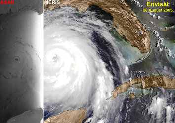
Hurricane Irene
This animation, comprised of two images taken simultaneously at 11:15 local time (15:15 GMT) on 27 August 2011 with different Envisat sensors, shows Hurricane Irene, which struck the US east coast at the end of August.
The first black and white radar image provides an unusual view of a hurricane as it shows the rough ocean surface through the clouds. In the centre of the image, a dark spot can be seen where the eye of the hurricane passed over North Carolina’s Outer Banks. This area of serene weather at the centre of the hurricane was visible to the radar because calm water provided a smooth surface, appearing darker. The second image is from Envisat’s MERIS instrument and shows the typical spiral cloud pattern of the hurricane.