About ESA
The European Space Agency (ESA) is Europe’s gateway to space. Its mission is to shape the development of Europe’s space capability and ensure that investment in space continues to deliver benefits to the citizens of Europe and the world.
Highlights


Latest


Space in Member States
Find out more about space activities in our 23 Member States, and understand how ESA works together with their national agencies, institutions and organisations.
 Germany
 Austria
 Belgium
 Denmark
 Spain
Spain
 Estonia
 Finland
 France
 Greece
 Hungary
 Ireland
 Italy
Italy
 Luxembourg
 Norway
 The Netherlands
 Poland
 Portugal
 Czechia
 Romania
 United Kingdom
 Slovenia
 Sweden
 Switzerland
Science & Exploration
Exploring our Solar System and unlocking the secrets of the Universe
Go to topicAstronauts


Latest


Enabling & Support
Making space accessible and developing the technologies for the future
Go to topicLatest


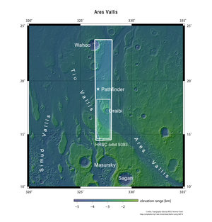
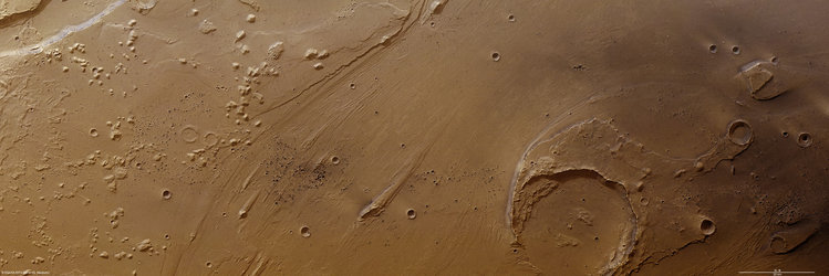
Features in Ares Vallis
Oraibi crater [box 1] is about 32 km across. It is filled with sediments and part of its rim has been eroded by water. This indicates that in the distant past large volumes of water must have rushed through the Ares Vallis. The great outflow also cut stepped riverbanks [box 2] and excavated parallel channels in the riverbed that indicate the flow path. Streamlined islands [box 3] have been left standing above the valley floor, again indicating the direction taken by the water.
There are ghost craters [box 4], both on the floor and on the plateau to the left of the image. These were once fully formed craters that water and wind have since eroded and filled with sediments. Also in this area is an ejecta blanket made of material thrown across the martian surface during the formation of an impact crater. In the upper left corner is a landslide [box 5] roughly 4 km wide, probably caused by the same impact that created the ejecta. Clusters and aligned groups of small craters in the image are likely related to the same event: they are not eroded and must have been formed in the very recent past.
The image was acquired by Mars Express at about 16°N/327°E during orbit 9393 on 11 May 2011. The images have a ground resolution of 15 m per pixel.