About ESA
The European Space Agency (ESA) is Europe’s gateway to space. Its mission is to shape the development of Europe’s space capability and ensure that investment in space continues to deliver benefits to the citizens of Europe and the world.
Highlights


Latest


Space in Member States
Find out more about space activities in our 23 Member States, and understand how ESA works together with their national agencies, institutions and organisations.
 Germany
 Austria
 Belgium
 Denmark
 Spain
Spain
 Estonia
 Finland
 France
 Greece
 Hungary
 Ireland
 Italy
Italy
 Luxembourg
 Norway
 The Netherlands
 Poland
 Portugal
 Czechia
 Romania
 United Kingdom
 Slovenia
 Sweden
 Switzerland
Science & Exploration
Exploring our Solar System and unlocking the secrets of the Universe
Go to topicAstronauts


Latest


Enabling & Support
Making space accessible and developing the technologies for the future
Go to topicLatest


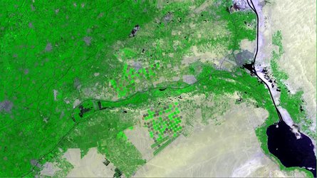
Agricultural structure in Kansas
This false-colour Landsat-5 image from 4 May 2012 shows agricultural structures in the US state of Kansas.
The Midwestern state’s agricultural outputs include cattle, sheep, wheat, soybeans, cotton, corn and salt. Kansas is also one of the top ten states in US oil production.
The cropland is divided into circles and rectangles due to the different types of irrigation systems.
Circles come from a central-pivot system, where the long water pipe rotates around a well at the centre, while rectangles are made when the pipes are rolled in straight lines across the fields.
The false colour makes vegetation look mostly red and brown in this image, allowing for better discrimination between different vegetation types.
This is helpful when satellite data are used in agricultural monitoring for mapping and classifying land use, crop type, crop health, change detection, irrigated landscape mapping and crop area mapping.
In the bottom right corner, the agricultural patchwork breaks for the Cimarron River. Sometimes, the water in this river disappears entirely under the sand in the river bed.
In the central right portion of the image is the city of Ulysses. Home to about 6000, it sits 65 km north of Kansas’s border with Oklahoma, and 65 km east of the border with Colorado.
The Thematic Mapper on Landsat-5 is jointly managed by NASA and the US Geological Survey. ESA supports the Landsat series as a Third Party Mission, meaning it uses its ground infrastructure and expertise to acquire, process and distribute Landsat data to users.
This image is featured on the Earth from Space video programme.