About ESA
The European Space Agency (ESA) is Europe’s gateway to space. Its mission is to shape the development of Europe’s space capability and ensure that investment in space continues to deliver benefits to the citizens of Europe and the world.
Highlights


Latest


Space in Member States
Find out more about space activities in our 23 Member States, and understand how ESA works together with their national agencies, institutions and organisations.
 Germany
 Austria
 Belgium
 Denmark
 Spain
Spain
 Estonia
 Finland
 France
 Greece
 Hungary
 Ireland
 Italy
Italy
 Luxembourg
 Norway
 The Netherlands
 Poland
 Portugal
 Czechia
 Romania
 United Kingdom
 Slovenia
 Sweden
 Switzerland
Science & Exploration
Exploring our Solar System and unlocking the secrets of the Universe
Go to topicAstronauts


Latest


Enabling & Support
Making space accessible and developing the technologies for the future
Go to topicLatest


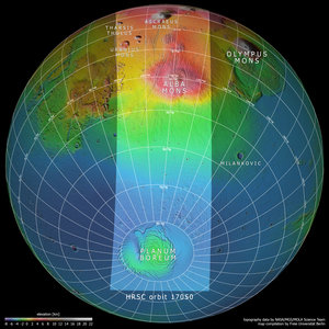
Topography of Tharsis region on Mars
This context map is based on data from the Mars Orbiter Laser Altimeter (MOLA) experiment onboard NASA’s Mars Global Surveyor (MGS) mission. It shows the slice of Mars captured by the High Resolution Stereo Camera aboard ESA’s Mars Express spacecraft to celebrate the mission’s 15th anniversary: the intriguing and once-active Tharsis province.
Included in this labelled view is the extensive canyon system of Valles Marineris, the web-like system of fissures comprising Noctis Labyrinthus, two out of four volcanoes, the north pole, and the so-called Martian dichotomy: the difference in altitude between the northern and southern regions of Mars. Areas at higher altitudes are shown in red-orange tones, while those at lower ones are displayed in blue-greens (as indicated by the scale to the bottom left).
This map was created by the Planetary Sciences and Remote Sensing group at Freie Universität Berlin, Germany.

Topography and context of Tharsis and surroundings
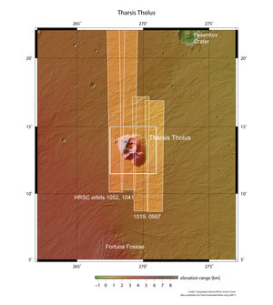
Tharsis Tholus in context

Location map of the Tharsis region on Mars
Mars topography