Accept all cookies Accept only essential cookies See our Cookie Notice

About ESA
The European Space Agency (ESA) is Europe’s gateway to space. Its mission is to shape the development of Europe’s space capability and ensure that investment in space continues to deliver benefits to the citizens of Europe and the world.
Highlights
ESA - United space in Europe
This is ESA ESA facts Member States & Cooperating States Funding Director General Top management For Member State Delegations European vision European Space Policy ESA & EU Space Councils Responsibility & Sustainability Annual Report Calendar of meetings Corporate newsEstablishments & sites
ESA Headquarters ESA ESTEC ESA ESOC ESA ESRIN ESA EAC ESA ESAC Europe's Spaceport ESA ESEC ESA ECSAT Brussels Office Washington OfficeWorking with ESA
Business with ESA ESA Commercialisation Gateway Law at ESA Careers Cyber resilience at ESA IT at ESA Newsroom Partnerships Merchandising Licence Education Open Space Innovation Platform Integrity and Reporting Administrative Tribunal Health and SafetyMore about ESA
History ESA Historical Archives Exhibitions Publications Art & Culture ESA Merchandise Kids Diversity ESA Brand Centre ESA ChampionsLatest
Space in Member States
Find out more about space activities in our 23 Member States, and understand how ESA works together with their national agencies, institutions and organisations.
Science & Exploration
Exploring our Solar System and unlocking the secrets of the Universe
Go to topicAstronauts
Missions
Juice Euclid Webb Solar Orbiter BepiColombo Gaia ExoMars Cheops Exoplanet missions More missionsActivities
International Space Station Orion service module Gateway Concordia Caves & Pangaea BenefitsLatest
Space Safety
Protecting life and infrastructure on Earth and in orbit
Go to topicAsteroids
Asteroids and Planetary Defence Asteroid danger explained Flyeye telescope: asteroid detection Hera mission: asteroid deflection Near-Earth Object Coordination CentreSpace junk
About space debris Space debris by the numbers Space Environment Report In space refuelling, refurbishing and removingSafety from space
Clean Space ecodesign Zero Debris Technologies Space for Earth Supporting Sustainable DevelopmentLatest
Applications
Using space to benefit citizens and meet future challenges on Earth
Go to topicObserving the Earth
Observing the Earth Future EO Copernicus Meteorology Space for our climate Satellite missionsCommercialisation
ESA Commercialisation Gateway Open Space Innovation Platform Business Incubation ESA Space SolutionsLatest
Enabling & Support
Making space accessible and developing the technologies for the future
Go to topicBuilding missions
Space Engineering and Technology Test centre Laboratories Concurrent Design Facility Preparing for the future Shaping the Future Discovery and Preparation Advanced Concepts TeamSpace transportation
Space Transportation Ariane Vega Space Rider Future space transportation Boost! Europe's Spaceport Launches from Europe's Spaceport from 2012Latest
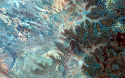
Lake Disappointment, Australia
Thank you for liking
You have already liked this page, you can only like it once!
The Copernicus Sentinel-2A satellite takes us over Lake Disappointment in northwest Australia. Found in one of the most remote areas of the country, it is believed to have been discovered by an early explorer called Frank Hann in 1897. He was convinced that the series of creeks that he had been following in the east Pilbara area would lead to a freshwater lake and drinking water supply. Such was his disappointment to find a salt lake at the end of his journey, he gave the lake its memorable name.
Although the lake is dry most of the time, it is home to many species of water birds. When it is full, primarily during very wet periods, the lake retains water and allows no outflow and is hence classified as an endorheic basin.
In this false-colour image, the differences in the shades of blue in the lake reflect the depth of the water. The darker the blue, the deeper the water is. A higher concentration of salt might also explain the different colours of the water round the edges of the lake.
It is likely that the red lines spread across the top part of the image represent some form of vegetation in this predominantly arid area on the edge of the Gibson Desert. Karlamilyi National Park, Western Australia's largest and most remote national park, can be found north of the lake. The park spans over 1.3 million hectares between the Great Sandy Desert and the Little Sandy Desert.
Covering an area of almost 380 000 sq km, the Shire of East Pilbara, also to the north of the lake, is the third largest municipality in the world. The population was registered as only around 11 000 in 2017, with mining constituting the backbone of the local economy.
The Sentinel-2 mission for Europe’s Copernicus programme is tasked with monitoring our changing lands. Designed specifically to monitor vegetation, it can also detect differences in sparsely vegetated areas, as well as the mineral composition of soil.
This image, which was captured on 1 April 2017, is also featured on the Earth from Space video programme.
-
CREDIT
contains modified Copernicus Sentinel data (2017), processed by ESA -
LICENCE
CC BY-SA 3.0 IGO or ESA Standard Licence
(content can be used under either licence)


 Germany
 Austria
 Belgium
 Denmark
 Spain
Spain
 Estonia
 Finland
 France
 Greece
 Hungary
 Ireland
 Italy
Italy
 Luxembourg
 Norway
 The Netherlands
 Poland
 Portugal
 Czechia
 Romania
 United Kingdom
 Slovenia
 Sweden
 Switzerland


