About ESA
The European Space Agency (ESA) is Europe’s gateway to space. Its mission is to shape the development of Europe’s space capability and ensure that investment in space continues to deliver benefits to the citizens of Europe and the world.
Highlights


Latest


Space in Member States
Find out more about space activities in our 23 Member States, and understand how ESA works together with their national agencies, institutions and organisations.
 Germany
 Austria
 Belgium
 Denmark
 Spain
Spain
 Estonia
 Finland
 France
 Greece
 Hungary
 Ireland
 Italy
Italy
 Luxembourg
 Norway
 The Netherlands
 Poland
 Portugal
 Czechia
 Romania
 United Kingdom
 Slovenia
 Sweden
 Switzerland
Science & Exploration
Exploring our Solar System and unlocking the secrets of the Universe
Go to topicAstronauts


Latest


Enabling & Support
Making space accessible and developing the technologies for the future
Go to topicLatest


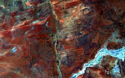
Lake MacKay, Australia
Brown hills speckle the eastern part of Australia’s Lake MacKay in this satellite image.
Located on the border of the states of Western Australia and Northern Territory, the salt lake only sees water after seasonal rainfall – if at all. It is classified as an ephemeral lake, meaning it exists only after precipitation. This is not the same as a seasonal lake, which sees water for longer periods.
About half of Australia's rivers drain inland and often end in ephemeral salt lakes.
The greens and blues in this image show desert vegetation or algae, soil moisture and minerals – mainly salt. On some of the brown ‘islands’ and on the shore in the lower right, we can see the east–west sand ridges forming lines in the landscape.
The lake lies at the edge of the Great Sandy Desert, which covers nearly 285 000 sq km. Roads are scarce in the area, and often frequented by four-wheel drive adventurers. Roads include the Canning Stock Route about 300 km to the west of the image, or Tanami Track connecting Australia’s Stuart Highway to the Great Northern Highway around 300 km to the east.
This image, also featured on the Earth from Space video programme, was captured by the Copernicus Sentinel-2B satellite on 15 March.
Although it is still being calibrated following the 7 March launch, the satellite’s main instrument is already delivering images, demonstrating its capability to map Earth’s land, coast and inland water bodies. Once fully operational, the data will be made available to users for a variety of applications, free of charge.