About ESA
The European Space Agency (ESA) is Europe’s gateway to space. Its mission is to shape the development of Europe’s space capability and ensure that investment in space continues to deliver benefits to the citizens of Europe and the world.
Highlights


Latest


Space in Member States
Find out more about space activities in our 23 Member States, and understand how ESA works together with their national agencies, institutions and organisations.
 Germany
 Austria
 Belgium
 Denmark
 Spain
Spain
 Estonia
 Finland
 France
 Greece
 Hungary
 Ireland
 Italy
Italy
 Luxembourg
 Norway
 The Netherlands
 Poland
 Portugal
 Czechia
 Romania
 United Kingdom
 Slovenia
 Sweden
 Switzerland
Science & Exploration
Exploring our Solar System and unlocking the secrets of the Universe
Go to topicAstronauts


Latest


Enabling & Support
Making space accessible and developing the technologies for the future
Go to topicLatest


Earth images in vogue
Images of Earth from space meet fashion this week as Vogue magazine features the ‘Fragility and Beauty’ exhibition in Milan, Italy. Through several satellite images, the Italian online edition of Vogue highlights how the exhibition creates a link between scientific research, space technology and art, focusing on the theme of climate change and sustainable development.
Organised by ESA and the Italian Space Agency and inaugurated in May this year, the ‘Fragility and Beauty’ exhibition can be seen at the Italian National Museum of Science and Technology in Milan.
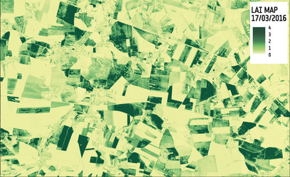
This image of northern Serbia is just one of the many beautiful images from space included in the exhibition.
Originally featured on ESA’s Earth from Space video programme, this particular image was taken by the Copernicus Sentinel-2 mission on 28 August 2016. It is a false-colour image, and apart from being beautiful, the different colours indicate varying vegetative states. For example, yellowish patches indicate soil or freshly ploughed land, while shades of blue (primarily in the lower left) indicate either the same crop or different crops at a similar stage of growth.
The two Copernicus Sentinel-2 satellites each carry an instrument that has 13 spectral bands, designed to provide images that can be used to distinguish between different crop types as well as data on numerous plant features, such as active chlorophyll content and leaf water content, all of which are essential to accurately monitor plant growth.
This kind of information helps informed decisions to be made, whether they are about deciding how much water or fertiliser is needed for a maximum harvest or for forming strategies to address climate change.