About ESA
The European Space Agency (ESA) is Europe’s gateway to space. Its mission is to shape the development of Europe’s space capability and ensure that investment in space continues to deliver benefits to the citizens of Europe and the world.
Highlights


Latest


Space in Member States
Find out more about space activities in our 23 Member States, and understand how ESA works together with their national agencies, institutions and organisations.
 Germany
 Austria
 Belgium
 Denmark
 Spain
Spain
 Estonia
 Finland
 France
 Greece
 Hungary
 Ireland
 Italy
Italy
 Luxembourg
 Norway
 The Netherlands
 Poland
 Portugal
 Czechia
 Romania
 United Kingdom
 Slovenia
 Sweden
 Switzerland
Science & Exploration
Exploring our Solar System and unlocking the secrets of the Universe
Go to topicAstronauts


Latest


Enabling & Support
Making space accessible and developing the technologies for the future
Go to topicLatest


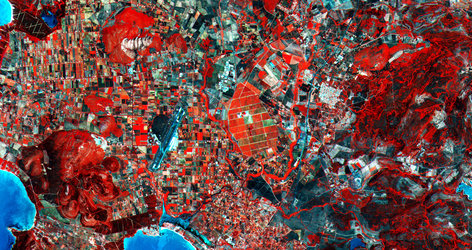
Sardinia, Italy
Sardinia, the second-largest island in the Mediterranean Sea, is featured in this false-colour image captured by the Copernicus Sentinel-2 mission.
Zoom in to see this image at its full 20 m resolution or click on the circles to learn more about the features in this image.
Sardinia (also known as Sardegna) is situated between the Mediterranean Sea to the west and south and the Tyrrhenian Sea to the east. The island sits 200 km west of the Italian Peninsula, 200 km north of Tunisia and around 12 km south of the French island of Corsica, partially visible in the top of the image.
This image, which uses data from 11 October to 14 October 2019, has been processed using the shortwave infrared band and the near infrared band to highlight dense vegetation. Crops and vegetation appear in bright green in the image, while bare soil can be seen in various shades of orange and brown.
Grasslands and croplands with a higher moisture content appear more vibrant in the image. As water is a strong absorber of infrared, inland water bodies are delineated and can be easily spotted in black. Much of the Sardinia’s arable land is devoted to cereal cultivation and fruit growing.
Sardinia is a mainly mountainous region, with its highest point Mount La Marmora in the Gennargentu massif visible in the centre-right of the image. With over 1800 km of coastline, Sardinia is internationally renowned for its beaches including those along the Emerald Coast, or Costa Smeralda, Alghero and Villasimius. The coasts, particularly in the east, are high and rocky, with long stretches of coastline with bays, inlets and various smaller islands located off the coast.
The archipelago of La Maddalena, including the renowned islands of La Maddalena, Caprera and Santo Stefano, can be seen in the top-right of the image. Its islands are known for their pristine beaches and wild beauty. Cagliari, the island’s capital and largest city, lies on the southern coast of the island.
Copernicus Sentinel-2 is designed to provide images that can be used to distinguish between different crop types as well as data on numerous plant indices, such as leaf area index, leaf chlorophyll content and leaf water content – all of which are essential to accurately monitor plant growth.
This image is also featured on the Earth from Space video programme.