About ESA
The European Space Agency (ESA) is Europe’s gateway to space. Its mission is to shape the development of Europe’s space capability and ensure that investment in space continues to deliver benefits to the citizens of Europe and the world.
Highlights


Latest


Space in Member States
Find out more about space activities in our 23 Member States, and understand how ESA works together with their national agencies, institutions and organisations.
 Germany
 Austria
 Belgium
 Denmark
 Spain
Spain
 Estonia
 Finland
 France
 Greece
 Hungary
 Ireland
 Italy
Italy
 Luxembourg
 Norway
 The Netherlands
 Poland
 Portugal
 Czechia
 Romania
 United Kingdom
 Slovenia
 Sweden
 Switzerland
Science & Exploration
Exploring our Solar System and unlocking the secrets of the Universe
Go to topicAstronauts


Latest


Enabling & Support
Making space accessible and developing the technologies for the future
Go to topicLatest


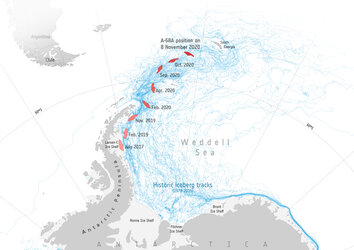
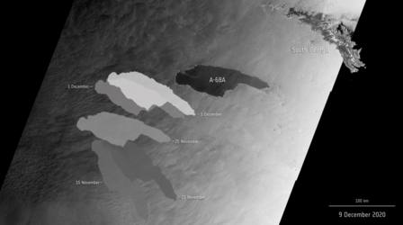
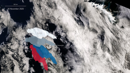
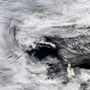
Iceberg A-68A: hit or miss?
An enormous iceberg, called A-68A, has made headlines over the past weeks as it drifts towards South Georgia in the Southern Ocean. New images, captured by the Copernicus Sentinel-1 mission, show the berg is rotating and potentially drifting westwards.
In July 2017, the lump of ice, more than twice the size of Luxembourg, broke off Antarctica’s Larsen C ice shelf – spawning one of the largest icebergs on record. Now, three years later, the A68A berg is being carried by currents in open waters – thousands of kilometres from its birthplace.
The Copernicus Sentinel-1 mission’s latest acquisition, captured on 25 November, shows the berg’s eastern tip is now just 255 km from South Georgia. If the iceberg were to reach the island’s shores, it could potentially ground in the shallow waters offshore and threaten wildlife, including penguins, seals and krill.
As these animals need access to the sea to feed, the iceberg could easily block their foraging routes – preventing them from feeding their young. It could also disturb the ecosystem below by crushing animal and plant life on the seafloor.
Satellite missions are being used to track the berg on its journey over the past three years. The Sentinel-1 radar mission, with its ability to see through clouds and the dark, has been instrumental in mapping the polar regions in winter.