About ESA
The European Space Agency (ESA) is Europe’s gateway to space. Its mission is to shape the development of Europe’s space capability and ensure that investment in space continues to deliver benefits to the citizens of Europe and the world.
Highlights


Latest


Space in Member States
Find out more about space activities in our 23 Member States, and understand how ESA works together with their national agencies, institutions and organisations.
 Germany
 Austria
 Belgium
 Denmark
 Spain
Spain
 Estonia
 Finland
 France
 Greece
 Hungary
 Ireland
 Italy
Italy
 Luxembourg
 Norway
 The Netherlands
 Poland
 Portugal
 Czechia
 Romania
 United Kingdom
 Slovenia
 Sweden
 Switzerland
Science & Exploration
Exploring our Solar System and unlocking the secrets of the Universe
Go to topicAstronauts


Latest


Enabling & Support
Making space accessible and developing the technologies for the future
Go to topicLatest


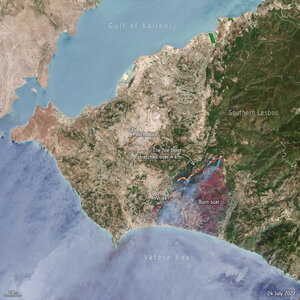
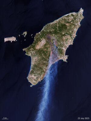
Wildfires ravage Greek island of Evia
Parts of the Mediterranean and central Europe have experienced extreme temperatures this summer, with wildfires causing devastation in both Turkey and Greece. The blaze on Evia, Greece’s second-largest island, is one of the worst hit with fires having burned down large forested areas, homes and businesses – forcing thousands to evacuate by sea to save their lives.
This false-colour Copernicus Sentinel-2 image was captured yesterday on 11 August, and has been processed in a way that included the near-infrared channel which is usually used to highlight vegetation (visible in bright red). The image shows the extent of the burned area (visible in shades of brown and green) in the northern part of the island which has suffered the most damage, with an estimated 50 000 hectares lost.
The blaze, fuelled by strong winds, began on 3 August and is still ongoing, with hundreds of firefighters currently tackling the flames.
The heatwave has seen some countries record their highest temperature in decades, with the Italian island of Sicily registering 48.8°C, which may be Europe’s hottest temperature on record. Wildfires have also been raging in other parts of Greece, Italy, Albania and Algeria, prompting activations in the Copernicus Emergency Mapping Service. The mapping service uses data from satellites to aid response to disasters such as wildfires and floods.