About ESA
The European Space Agency (ESA) is Europe’s gateway to space. Its mission is to shape the development of Europe’s space capability and ensure that investment in space continues to deliver benefits to the citizens of Europe and the world.
Highlights


Latest


Space in Member States
Find out more about space activities in our 23 Member States, and understand how ESA works together with their national agencies, institutions and organisations.
 Germany
 Austria
 Belgium
 Denmark
 Spain
Spain
 Estonia
 Finland
 France
 Greece
 Hungary
 Ireland
 Italy
Italy
 Luxembourg
 Norway
 The Netherlands
 Poland
 Portugal
 Czechia
 Romania
 United Kingdom
 Slovenia
 Sweden
 Switzerland
Science & Exploration
Exploring our Solar System and unlocking the secrets of the Universe
Go to topicAstronauts


Latest


Enabling & Support
Making space accessible and developing the technologies for the future
Go to topicLatest


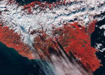
Calabria, Italy
Calabria, often referred to as the ‘boot’ of Italy, is featured in this image captured by the Copernicus Sentinel-2 mission.
Zoom in to see this image at its full resolution or click on the circles to learn more about the features in it.
Calabria is a region in southern Italy, famous for its irregular shape that stretches from north to south for around 250 km – separating the Tyrrhenian Sea to the west and the Ionian Sea to the east. The region covers an area of around 15 000 sq km (with over 740 km of coastline) of which agricultural land covers 49%.
Most of the region is mountainous or hilly with three mountain ranges present: Pollino (not visible), La Sila and Aspromonte.
La Sila is a vast mountainous plateau around 1200 m above sea level, stretching for nearly 2000 sq km along the central area of Calabria. The highest point is Botte Donato, which reaches around 1928 m. The Aspromonte massif forms the southernmost tip of the Italian peninsula bordered by the sea on three sides. The highest peak is Montalto at 1955 m.
Calabria is separated from Sicily by the Strait of Messina, visible in the bottom-left, where the narrowest point between Capo Peloro in Sicily and Punta Pezzo in Calabria is only around 3.2 km.
Almost 2 million people reside in Calabria, with Reggio Calabria being the most populous city in the region (with an estimated population of around 200 000 people). The city lies on the ‘toe’ of the Italian Peninsula, on the slopes of the Aspromonte mountain range.
Calabria is known for its tourism, with its main attractions being the rugged cliffs and sandy beaches. Some of these main destinations include Tropea, Scilla, Lamezia Terme and Praia a Mare.
As well as providing detailed information about Earth’s vegetation, the Copernicus Sentinel-2 mission is designed to play a key role in mapping differences in land cover to understand the landscape, map how it is used and monitor changes over time.
This image is also featured on the Earth from Space video programme.