About ESA
The European Space Agency (ESA) is Europe’s gateway to space. Its mission is to shape the development of Europe’s space capability and ensure that investment in space continues to deliver benefits to the citizens of Europe and the world.
Highlights


Latest


Space in Member States
Find out more about space activities in our 23 Member States, and understand how ESA works together with their national agencies, institutions and organisations.
 Germany
 Austria
 Belgium
 Denmark
 Spain
Spain
 Estonia
 Finland
 France
 Greece
 Hungary
 Ireland
 Italy
Italy
 Luxembourg
 Norway
 The Netherlands
 Poland
 Portugal
 Czechia
 Romania
 United Kingdom
 Slovenia
 Sweden
 Switzerland
Science & Exploration
Exploring our Solar System and unlocking the secrets of the Universe
Go to topicAstronauts


Latest


Enabling & Support
Making space accessible and developing the technologies for the future
Go to topicLatest


UK heatwave
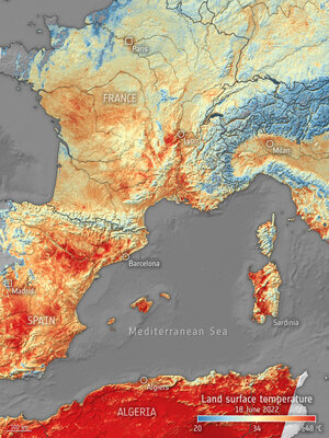
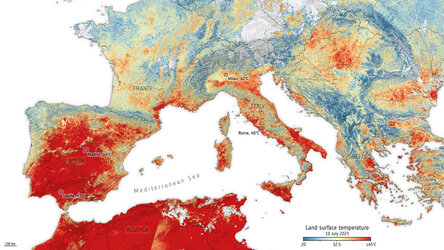
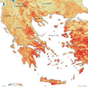
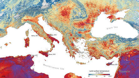
This summer, heatwaves struck Europe, North Africa, the US and Asia with temperatures reaching over 40°C in places – breaking many long-standing records. Images from the Copernicus Sentinel-3 mission show the scale of Britain’s heatwave as it baked in extreme temperatures in August.
Zoom in to see this image at its full resolution or click on the circles to learn more about the features in it.
The image, captured on 12 August 2022, shows the United Kingdom’s previously green land appear brown (particularly in the southeast) amid the scorching conditions. The heatwave comes after months of extreme temperatures and low rainfall left the landscape parched. The dry conditions are also visible in parts of France, Belgium and the Netherlands.
The severe heatwaves experienced across Europe this summer are a harsh reminder of what is in store for our future. Extreme weather events will happen more frequently and intensely according to the Intergovernmental Panel on Climate Change (IPCC). This trend is set to worsen unless the rise in atmospheric greenhouse gas emissions caused by human activities is addressed.
Satellites orbiting our planet play an important role in delivering data to understand and monitor how our world is changing. Their observations and data are critical for improving model predictions of our future climate, mitigation strategies and policymaking.
The Copernicus Sentinel-3 mission not only provides two-day global coverage optical data, but it also carries a Sea and Land Surface Temperature Radiometer instrument that measures Earth’s land surface temperature (how hot the actual surface would feel to touch). During August 2022, the Sentinel-3 mission recorded extreme land surface temperatures of more than 45°C in the United Kingdom, 50°C in France and 60°C in Spain.
Sentinel-3 data has also been merged with archived satellite observations to form a recently released 25-year record of global land surface temperatures (from 1995 to 2020) developed by ESA’s Climate Change Initiative along with Europe’s leading climate scientists. This data record shows a stable increase in global land surface temperature of 0.2°C per decade, with strong regional variability.
Monitoring land-surface temperatures is useful for scientists because the warmth rising from Earth’s surface influences weather and climate patterns. These measurements are particularly important for farmers evaluating how much water their crops need and for urban planners looking to improve heat-mitigating strategies.
This image is also featured on the Earth from Space video programme.