About ESA
The European Space Agency (ESA) is Europe’s gateway to space. Its mission is to shape the development of Europe’s space capability and ensure that investment in space continues to deliver benefits to the citizens of Europe and the world.
Highlights


Latest


Space in Member States
Find out more about space activities in our 23 Member States, and understand how ESA works together with their national agencies, institutions and organisations.
 Germany
 Austria
 Belgium
 Denmark
 Spain
Spain
 Estonia
 Finland
 France
 Greece
 Hungary
 Ireland
 Italy
Italy
 Luxembourg
 Norway
 The Netherlands
 Poland
 Portugal
 Czechia
 Romania
 United Kingdom
 Slovenia
 Sweden
 Switzerland
Science & Exploration
Exploring our Solar System and unlocking the secrets of the Universe
Go to topicAstronauts


Latest


Enabling & Support
Making space accessible and developing the technologies for the future
Go to topicLatest


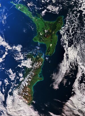
Earth from Space: Cook Strait, New Zealand
The Copernicus Sentinel-2 mission takes us over Cook Strait, which separates New Zealand's North and South Islands.
Zoom in to explore this image at its full 10 m resolution or click on the circles to learn more.
Named after James Cook, who was the first European to sail through it, the Cook Strait is just 23 km wide at its narrowest point, so on a clear day it is possible to see across the strait. However, it is also renowned as one of the roughest and most unpredictable stretches of water in the world, owing to strong winds, conflicting currents and variable tides.
This dynamic environment is depicted here by the various shades of blue in the water and swirls. Both shores feature steep cliffs which, in the image, result in the white colour caused by the big waves crashing against the rocky coast.
New Zealand comprises many islands, though the North and South Islands are the largest. North Island, visible on the right, is home to Wellington, New Zealand’s capital city, which lies on the hills and shore around the bay in the extreme south of the island.
South Island is connected to North Island by a ferry service from Wellington to Picton, a port town near the head of Queen Charlotte Sound. The sound is a deep inlet visible in dark blue in the upper part of South Island. Numerous ferries can be spotted as white dots in the sound.
Moving south, a patchwork of agricultural fields cover the Wairau Plain and surround the town of Blenheim, visible in grey.
Several rivers cross the plain. The biggest in the image, the Wairau River, is one of the longest in New Zealand. It can be seen meandering through the fields and splitting into separate arms which eventually enter Cloudy Bay in Cook Strait. The southernmost arm of the river forms an estuary, which feeds a network of ponds, marshes and lagoons, sheltered from the Pacific Ocean by an 8-km-long boulder bank.