About ESA
The European Space Agency (ESA) is Europe’s gateway to space. Its mission is to shape the development of Europe’s space capability and ensure that investment in space continues to deliver benefits to the citizens of Europe and the world.
Highlights


Latest


Space in Member States
Find out more about space activities in our 23 Member States, and understand how ESA works together with their national agencies, institutions and organisations.
 Germany
 Austria
 Belgium
 Denmark
 Spain
Spain
 Estonia
 Finland
 France
 Greece
 Hungary
 Ireland
 Italy
Italy
 Luxembourg
 Norway
 The Netherlands
 Poland
 Portugal
 Czechia
 Romania
 United Kingdom
 Slovenia
 Sweden
 Switzerland
Science & Exploration
Exploring our Solar System and unlocking the secrets of the Universe
Go to topicAstronauts


Latest


Enabling & Support
Making space accessible and developing the technologies for the future
Go to topicLatest


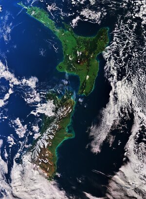
Earth from Space: New Zealand’s North Island
Captured on 7 May 2024, this Copernicus Sentinel-2 image shows part of New Zealand’s North Island.
Zoom in to explore this image at its full 10 m resolution or click on the circles to learn more.
New Zealand lies in the South Pacific Ocean and comprises two major islands – North and South – and a number of smaller islands.
Much of North Island’s terrain in this image is dominated by lush vegetation, with darker green areas denoting dense forested zones.
Urban centres appear in grey. Towards the top of the image, the city of Auckland can be seen as a large, grey area adjacent to the Hauraki Gulf to the east and the Manukau Harbour to the west. Auckland is the country’s most populous city and its largest port. A focal point for transportation, the city is also served by New Zealand’s leading international airport, which can be spotted in the centre of Manukau Harbour.
Moving south, the largest grey area in the middle of the image is Hamilton, one of the country’s most important inland centres. It straddles the Waikato River, the longest river in New Zealand, which can be seen as a dark, winding line across the bottom right of the image, bisecting Hamilton into two nearly symmetrical parts.
As it winds its course, the Waikato meanders through a patchwork of agricultural fields that cover the plain between Auckland and Hamilton. The green and brown hues of the fields shift according to the crop type and their various stages of growth.
Before entering the Tasman Sea, south of Auckland, the Waikato River forms an estuary, which feeds a network of marshes and creates numerous small islands.
On the coast, bright, turquoise colours in the Tasman Sea suggest the presence of sediment being carried into the ocean by river discharge. The swirls in the sea show how the currents transport sediment.
A number of lakes and wetlands can be spotted near the centre of the image, including the Whangamarino Wetland, an extensive mosaic of swamps and bogs, visible as a dark brown area east of the Waikato River. The Kopuatai Peat Dome, the largest, unaltered peat bog in New Zealand, is clear to see as the brown, elongated feature just south of the Hauraki Gulf.