About ESA
The European Space Agency (ESA) is Europe’s gateway to space. Its mission is to shape the development of Europe’s space capability and ensure that investment in space continues to deliver benefits to the citizens of Europe and the world.
Highlights


Latest


Space in Member States
Find out more about space activities in our 23 Member States, and understand how ESA works together with their national agencies, institutions and organisations.
 Germany
 Austria
 Belgium
 Denmark
 Spain
Spain
 Estonia
 Finland
 France
 Greece
 Hungary
 Ireland
 Italy
Italy
 Luxembourg
 Norway
 The Netherlands
 Poland
 Portugal
 Czechia
 Romania
 United Kingdom
 Slovenia
 Sweden
 Switzerland
Science & Exploration
Exploring our Solar System and unlocking the secrets of the Universe
Go to topicAstronauts


Latest


Enabling & Support
Making space accessible and developing the technologies for the future
Go to topicLatest


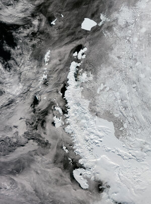
Earth from Space: Elephant Island
This rare, almost cloud-free view of the remote Elephant Island in Antarctica was captured in February 2023 by the Copernicus Sentinel-2 mission.
Zoom in to explore this image at its full 10 m resolution or click on the circles to learn more.
Lying in the Southern Ocean about 250 km northeast off the tip of the Antarctic Peninsula, Elephant Island is one of the outermost of the South Shetland Islands. It owes its name to both the sighting of elephant seals along its shores and its elephant-like shape, here the ‘trunk’ is partially covered by clouds.
This mountainous island is covered by ice. The highest peaks are Mount Pendragon, which reaches around 970 m, visible on the southern end, and, moving northeast, Mount Elder, which reaches around 945 m.
North of Mount Elder, the wide Endurance Glacier can be seen in the centre of the image. It is the main discharge glacier on the island and drains to the south and into the Weddel Sea. Thin sea ice, visible in light blue in front of the calving front, separates the glacier terminus from the open ocean waters.
The variations in the colour of the waters surrounding the island are due to sediment eroded by the flow of ice and carried by meltwater into the ocean. Small icebergs can be spotted, particularly off the western coast, as little white dots speckling the water. The white lines along the island coasts are the result of big waves crashing against the rocky steep cliffs.
Dramatic changes in Antarctica’s ice have become synonymous with the climate crisis. The continued observations from satellites are key to surveying the remote polar regions. Satellites can monitor the melting ice sheets caused by rising temperatures and the subsequent rising of sea levels, as well as the impact on global ocean currents caused by the increased influx of freshwater into ocean. This is paramount to improving our understanding of the Earth system and to providing evidence on the impact of climate change.