About ESA
The European Space Agency (ESA) is Europe’s gateway to space. Its mission is to shape the development of Europe’s space capability and ensure that investment in space continues to deliver benefits to the citizens of Europe and the world.
Highlights


Latest


Space in Member States
Find out more about space activities in our 23 Member States, and understand how ESA works together with their national agencies, institutions and organisations.
 Germany
 Austria
 Belgium
 Denmark
 Spain
Spain
 Estonia
 Finland
 France
 Greece
 Hungary
 Ireland
 Italy
Italy
 Luxembourg
 Norway
 The Netherlands
 Poland
 Portugal
 Czechia
 Romania
 United Kingdom
 Slovenia
 Sweden
 Switzerland
Science & Exploration
Exploring our Solar System and unlocking the secrets of the Universe
Go to topicAstronauts


Latest


Enabling & Support
Making space accessible and developing the technologies for the future
Go to topicLatest


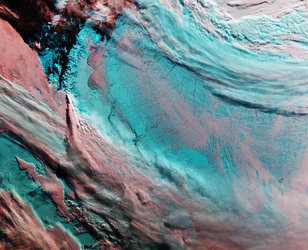
Earth from Space: Icy landscape
As the holiday season swiftly approaches, frosty landscapes tend to be associated with the magical idea of a white Christmas. But this Copernicus Sentinel-3 image over the Antarctic Peninsula sheds light on a different perspective.
Zoom in to explore this image at its full resolution or click on the circles to learn more.
The Antarctic Peninsula is the northernmost and warmest region of the Antarctic continent. It resembles a 1000-km-long arm covered with ice, stretching towards the southern tip of South America.
The peninsula’s west coast features over 100 large glaciers and numerous islands, including the big Adelaide Island, visible at the bottom of the image. Moving north, we see the Biscoe Islands, Anvers and Brabant islands, and the South Shetland Islands, separated from the northwestern tip of the peninsula by the Bransfield Strait.
Visible further north, Elephant and Clarence Islands are the outermost of the South Shetland archipelago. To the east is the A23a iceberg, currently the largest berg in the world. It calved from the Filchner-Ronne ice shelf in West Antarctica in 1986, but only recently, driven by winds and currents, started drifting quickly away from Antarctic waters. Like most icebergs from the Weddell Sea, A23a is likely to end up in the South Atlantic on a path called iceberg alley.
Thick ice shelves lie along the eastern side of the Peninsula, including the renowned Larsen Ice Shelf, a series of three shelves – A (the smallest), B, and C (the largest) – extending into the Weddel Sea.
Like many places on Earth, the Antarctic Peninsula has experienced warming over recent decades. This warming is believed to have triggered the retreat and break-up of the Larsen-B Ice Shelf, and the Larsen-A Ice Shelf, which disintegrated almost completely in January 1995.
Antarctica is surrounded by ice shelves, but there are increasing reports about them thinning and even collapsing. Studying ice shelves is important because they are indicators of climate change. In fact, Antarctica’s shrinking ice sheets are considered a climate tipping point. According to the Intergovernmental Panel on Climate Change (IPCC), tipping points are ‘critical thresholds in a system that, when exceeded, can lead to a significant change in the state of the system, often with an understanding that the change is irreversible.’
Using satellites to monitor Antarctica over decades is essential, because the data they return provides authoritative evidence of trends and allows scientists to make predictions about the continent’s future.