About ESA
The European Space Agency (ESA) is Europe’s gateway to space. Its mission is to shape the development of Europe’s space capability and ensure that investment in space continues to deliver benefits to the citizens of Europe and the world.
Highlights


Latest


Space in Member States
Find out more about space activities in our 23 Member States, and understand how ESA works together with their national agencies, institutions and organisations.
 Germany
 Austria
 Belgium
 Denmark
 Spain
Spain
 Estonia
 Finland
 France
 Greece
 Hungary
 Ireland
 Italy
Italy
 Luxembourg
 Norway
 The Netherlands
 Poland
 Portugal
 Czechia
 Romania
 United Kingdom
 Slovenia
 Sweden
 Switzerland
Science & Exploration
Exploring our Solar System and unlocking the secrets of the Universe
Go to topicAstronauts


Latest


Enabling & Support
Making space accessible and developing the technologies for the future
Go to topicLatest


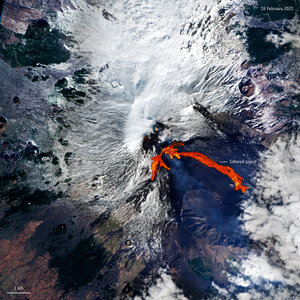
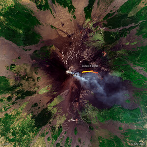
Italy's Mount Etna spews lava
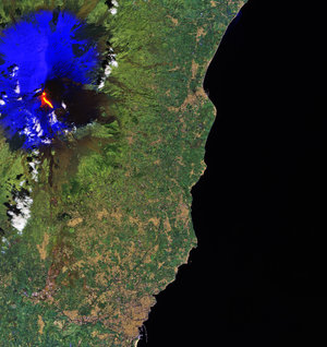
One of the world’s most active volcanoes, Mount Etna, erupted on Sunday – spewing lava and clouds of ash high over the Mediterranean island of Sicily. This image, captured on 13 November by the Copernicus Sentinel-2 mission, has been processed using the mission’s shortwave-infrared bands to show the lava flow at the time of acquisition.
Standing at approximately 3329 m high, Mount Etna is an almost constant state of activity. Ash and cloud created because of frequent eruptions pose a threat to the nearby city of Catania, situated on Sicily’s coast.
Footage of the most recent event was shared on social media, showing huge plumes of molten rock and lava shot into the night sky. Despite the volcano’s activity and ash precipitation, Catania Airport has remained open.
Mount Etna isn’t the sole volcano under surveillance in Europe. Iceland is also bracing itself for an impending volcanic eruption. Earthquake swarms have been recorded in the town of Grindavik as a magma tunnel forms beneath the region – prompting the evacuation of thousands of people.
Satellite data can be used to detect the slight signs of change that may foretell an eruption. Once an eruption begins, optical and radar instruments can capture the various phenomena associated with it, including lava flows, mudslides, ground fissures and earthquakes. Atmospheric sensors on satellites can also identify the gases and aerosols released by the eruption, as well as quantify their wider environmental impact.
Learn more about how the Copernicus Sentinel satellites can detect and track volcanic gas emissions, changes in ground deformation as well as volcanic ash plumes by clicking here.