About ESA
The European Space Agency (ESA) is Europe’s gateway to space. Its mission is to shape the development of Europe’s space capability and ensure that investment in space continues to deliver benefits to the citizens of Europe and the world.
Highlights


Latest


Space in Member States
Find out more about space activities in our 23 Member States, and understand how ESA works together with their national agencies, institutions and organisations.
 Germany
 Austria
 Belgium
 Denmark
 Spain
Spain
 Estonia
 Finland
 France
 Greece
 Hungary
 Ireland
 Italy
Italy
 Luxembourg
 Norway
 The Netherlands
 Poland
 Portugal
 Czechia
 Romania
 United Kingdom
 Slovenia
 Sweden
 Switzerland
Science & Exploration
Exploring our Solar System and unlocking the secrets of the Universe
Go to topicAstronauts


Latest


Enabling & Support
Making space accessible and developing the technologies for the future
Go to topicLatest


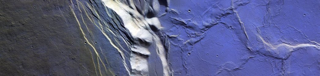
ExoMars spies frost on Ceraunius Tholus
Researchers have discovered frost atop volcanoes near Mars’s equator for the first time – a part of the planet where it was thought impossible for frost to form. The finding used observations from two ESA ExoMars Trace Gas Orbiter (TGO) instruments – CaSSIS and NOMAD – with additional imaging by ESA’s Mars Express.
This image shows frost on the caldera floor of the Ceraunius Tholus volcano. The frost is shown in blue. This blue colour is due to the way in which CaSSIS constructs its images, using both near-infrared and visible channels – a so-called ‘NPB’ image, as opposed to a typical RGB (red-green-blue) image. This combines the instrument's near-infrared (N), panchromatic (P) and blue (B) filters. This provides more information on a feature’s spectral diversity in a large range of wavelengths invisible to the human eye. Read more on how CaSSIS constructs its blue-hued images, and how this allows us to explore the Red Planet.
These four frames show (A) a wide-angle contextual view of Ceraunius Tholus from NASA’s Mars Reconnaissance Orbiter’s Context Camera, with early morning observations made by CaSSIS overlaid within the blue-toned rectangle. This rectangle is shown close-up in frame (B), with an additional white rectangle marking out an even more zoomed-in image, shown in frame (C). (C) shows ubiquitous frost on the caldera floor, but none on the caldera rim. (D) shows a CaSSIS image of the same region acquired at a different time of day, when there is no frost present. Both the CaSSIS images shown in (B) and (D) were acquired using a similar observing setup, suggesting that the apparent presence of frost is unlikely to be due to any photometric effects. Image (B) was acquired in early northern spring, and (D) in late northern winter.
North is up in all frames, and image scales are indicated in the bottom-right of each frame. The Local Solar Time (LST) is shown for the two frames on the right, as is ‘incidence angle’ (i) and 'solar longitude’ (Ls). Incidence angle indicates where the Sun is in the sky; it is 0° when the Sun is directly overhead, and 90° at the horizon. Solar longitude marks the position of Mars in its orbit relative to the Sun, reflecting the martian seasons through the year for each hemisphere (0° when northern spring begins, 270° at winter solstice).