About ESA
The European Space Agency (ESA) is Europe’s gateway to space. Its mission is to shape the development of Europe’s space capability and ensure that investment in space continues to deliver benefits to the citizens of Europe and the world.
Highlights


Latest


Space in Member States
Find out more about space activities in our 23 Member States, and understand how ESA works together with their national agencies, institutions and organisations.
 Germany
 Austria
 Belgium
 Denmark
 Spain
Spain
 Estonia
 Finland
 France
 Greece
 Hungary
 Ireland
 Italy
Italy
 Luxembourg
 Norway
 The Netherlands
 Poland
 Portugal
 Czechia
 Romania
 United Kingdom
 Slovenia
 Sweden
 Switzerland
Science & Exploration
Exploring our Solar System and unlocking the secrets of the Universe
Go to topicAstronauts


Latest


Enabling & Support
Making space accessible and developing the technologies for the future
Go to topicLatest


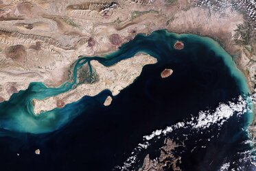
Earth from Space: Hainan Strait
The Copernicus Sentinel-2 mission takes us over the Hainan Strait in southern China.
Zoom in to explore this image at its full 10 m resolution or click on the circles to learn more.
The Hainan Strait, or Qiongzhou Strait, separates Guangdong's Leizhou Peninsula on China’s mainland to the north and the island province of Hainan to the south. It also connects the Gulf of Tonkin on the west to the South China Sea on the east.
Although narrow and shallow, the strait is a crucial maritime passage. Zooming in, a lot of boats can be spotted as white dots in the water, especially along the route connecting Hai'an Port, at the southern tip of the peninsula, to Haikou on Hainan Island. The water along the coasts is light brown owing to sediment.
The curved Leizhou Peninsula juts southward into the South China Sea. The largest island on the east coast, Donghai, forms two bays: Leizhou Bay to its south and Zhanjiang Bay to its north. Facing both bays are cities with the same names: Zhanjiang, the largest city on the peninsula, and Leizhou, which gave the peninsula its name.
Leizhou is surrounded by numerous greenhouses, visible as grey rectangles, while rice fields appear in shades of light brown, depending on the vegetation growth stage at the time of the image acquisition. The green area running along the city coast is a mixture of ponds, mangroves and mudflats.
Hainan Island dominates the bottom part of the image. The name Hainan means ‘south of the sea’, reflecting the island's position south of the strait. The capital Haikou can be seen in grey on the northern coast. Haikou is the island’s main port, situated to the west of the mouth of the Nandu River. Flowing northeast for over 300 km before draining into Haikou Bay, Nandu is the island’s longest river.
Two artificial islands, still under construction, can be seen off the Haikou coast: the circular-shaped Nanhai Pearl Island and Ruyi Island, off the northeast coast. Both islands will be holiday hubs connected by a bridge to the mainland, one of which is already visible south of Nanhai.