About ESA
The European Space Agency (ESA) is Europe’s gateway to space. Its mission is to shape the development of Europe’s space capability and ensure that investment in space continues to deliver benefits to the citizens of Europe and the world.
Highlights


Latest


Space in Member States
Find out more about space activities in our 23 Member States, and understand how ESA works together with their national agencies, institutions and organisations.
 Germany
 Austria
 Belgium
 Denmark
 Spain
Spain
 Estonia
 Finland
 France
 Greece
 Hungary
 Ireland
 Italy
Italy
 Luxembourg
 Norway
 The Netherlands
 Poland
 Portugal
 Czechia
 Romania
 United Kingdom
 Slovenia
 Sweden
 Switzerland
Science & Exploration
Exploring our Solar System and unlocking the secrets of the Universe
Go to topicAstronauts


Latest


Enabling & Support
Making space accessible and developing the technologies for the future
Go to topicLatest


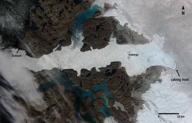
Earth from Space: Jakobshavn Glacier, Greenland
These summer images from the Copernicus Sentinel-2 and Sentinel-1 missions showcase different satellite views of Greenland’s west coast.
The optical Sentinel-2 image on the left, acquired on 5 August 2024, highlights the mouth of the Ilulissat Icefjord, clearly visible in white. This fjord is home to the Jakobshavn Glacier, known as Sermeq Kujalleq in Greenlandic, one of the fastest and most active glaciers in the world.
Jakobshavn Glacier drains approximately 6.5% of the Greenland ice sheet and produces around 10% of its icebergs. Many of these icebergs are so large that they become grounded in shallower areas of the fjord, where they remain for years until melting sufficiently to break apart and disperse.
Several icebergs in the image appear as white dots scattered across the fjord, speckling the waters of Disko Bay like stars in the night sky. These towering icebergs, some reaching heights of 100 m above the water, conceal even larger portions beneath the surface. Their shapes, sizes and colours vary greatly. Despite their appearance, some of the largest icebergs pictured here have a perimeter of 2 km.
Just north of the fjord’s mouth lies the small town of Ilulissat, with the town’s airport visible in light brown further north. Ilulissat, which means ‘icebergs’ in Greenlandic, is a popular destination for tourists who come to see the giant icebergs passing near the port.
The radar image on the right, captured on 03 August 2024 by Copernicus Sentinel-1, shows the positions of the giant bergs two days prior to the Sentinel-2 acquisition. By comparing these two images, the movement of the icebergs can be tracked. Their movement depends on various factors, including size, sea depth, currents and wind. In this region, icebergs typically drift northward towards Ilulissat.
Radar missions like Sentinel-1 are remarkably useful in monitoring sea ice, ice sheets and drifting icebergs, particularly in polar regions. Unlike optical imaging, radar can acquire images under any weather conditions, day or night.
On 5 December, Sentinel-1C, the third Copernicus Sentinel-1 satellite, was launched from Europe’s Spaceport in French Guiana. Along with its sibling Sentinel-1A already in orbit, Sentinel-1C will restore the mission to its full strength as a two-satellite constellation to continue support a diverse range of applications, such as environmental management, disaster response and climate change research.