About ESA
The European Space Agency (ESA) is Europe’s gateway to space. Its mission is to shape the development of Europe’s space capability and ensure that investment in space continues to deliver benefits to the citizens of Europe and the world.
Highlights


Latest


Space in Member States
Find out more about space activities in our 23 Member States, and understand how ESA works together with their national agencies, institutions and organisations.
 Germany
 Austria
 Belgium
 Denmark
 Spain
Spain
 Estonia
 Finland
 France
 Greece
 Hungary
 Ireland
 Italy
Italy
 Luxembourg
 Norway
 The Netherlands
 Poland
 Portugal
 Czechia
 Romania
 United Kingdom
 Slovenia
 Sweden
 Switzerland
Science & Exploration
Exploring our Solar System and unlocking the secrets of the Universe
Go to topicAstronauts


Latest


Enabling & Support
Making space accessible and developing the technologies for the future
Go to topicLatest


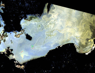
Irminger Sea ice swirl
The Copernicus Sentinel-2 mission takes us over a swirl of sea ice off the east coast of Greenland in the Irminger Sea, which is just south of the Denmark Strait between Greenland and Iceland.
Click on the box in the lower-right corner to view this image at its full 10 m resolution directly in your browser.
In this image captured on 9 June 2019, small pieces of sea ice, known as ice floes, trace out the ocean currents beneath, resulting in a large swirl-like feature of approximately 120 km in diameter.
This ice, which formed by freezing of the sea surface further north in the Arctic Ocean, has drifted southwards along the coast of Greenland before arriving at this location. The ice swirl is considered a typical eddy or vortex, commonly found in the summer marginal ice zone off the east coast of Greenland.
The marginal ice zone is the transition region from the open ocean, visible in dark blue, to the white sea ice. Depending on wind direction, waves and ocean currents, it can consist of small, isolated ice floes drifting over a large area to smaller ice floes pressed together in bright white bands.
Strong mesoscale air—ice—ocean interactive processes drive the advance and retreat of the sea ice edge, and result in the meanders or eddies visible in this region.
Investigations of such ocean eddies and meanders began in the 1970s and 1980s in the Greenland Sea to gain a better understanding of the interactions between the ocean, ice and atmosphere.
Copernicus Sentinel-2 is a two-satellite mission. Each satellite carries a high-resolution camera that images Earth’s surface in 13 spectral bands. Together they cover all Earth’s land surfaces, large islands, inland and coastal waters every five days at the equator.
This image is also featured on the Earth from Space video programme.