Germany
 Austria
 Belgium
 Denmark
 Spain
Spain
 Estonia
 Finland
 France
 Greece
 Hungary
 Ireland
 Italy
Italy
 Luxembourg
 Norway
 The Netherlands
 Poland
 Portugal
 Czechia
 Romania
 United Kingdom
 Slovenia
 Sweden
 Switzerland


EarthCARE profiles atmospheric particles in detail
Launched in May, ESA’s EarthCARE satellite has been making waves, with the first images from three of its scientific instruments already delivered. Now, the spotlight is firmly on the atmospheric lidar, the most advanced of the satellite’s four instruments.
This cutting-edge sensor has captured detailed 20 km-high vertical profiles of atmospheric aerosols – tiny particles and droplets from natural sources like wildfires, dust, and sea spray, and from human activities like industrial emissions or burning of wood – and clouds across various regions of the globe.
By emitting pulses of ultraviolet light and analysing the reflected signals, this unique lidar is used to measure the distribution and properties of aerosols and clouds, including their altitude, thickness, optical properties, and physical characteristics.
Working in unison with the satellite’s other three instruments, this is crucial for understanding the role of aerosols and clouds in Earth’s energy balance. The atmospheric lidar, in particular, will also deliver important input to improve air-quality forecasts.

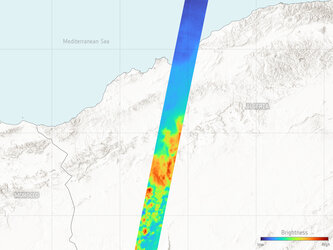
The first image here, from the atmospheric lidar on 2 August, offers a profile of polar stratospheric clouds over Antarctica. The grey strip below, as featured in all of the images, is the corresponding area captured in the infrared by EarthCARE’s multispectral imager instrument, which gives natural visual context to all of the instruments’ data.
Polar stratospheric clouds are crucial contributors to the depletion of stratospheric ozone during winter and spring. These clouds serve as surfaces for chemical reactions that generate chlorine free-radicals, which actively destroy ozone molecules in the stratosphere. This process is a key factor in the formation of the infamous ozone hole over Antarctica.
The jagged shape of the clouds in the centre-right is likely to be caused by gravity waves. Gravity waves form when air is forced upwards into a layer of stable air and gravity drags the air back down, creating a ripple effect – like the ripples of waves in the ocean.
These waves transfer energy and momentum from the lower atmosphere to the upper atmosphere, influencing weather patterns, general atmospheric circulation and impact the formation of polar stratospheric clouds.

The second image, captured on 4 August, is a strip over North America. Here, the presence of tropical storm Debby is clear to see over the Gulf of Mexico, as are large convective clouds further north. As these clouds are optically very thick, as can be seen in the multispectral imager information, the lidar captures details of the cloud tops, but cannot see below them.
Additionally, a striking red layer of aerosols is visible in the central part of the profile. These aerosols have been carried by the wind from forest fires that have been burning for a number of weeks in several regions of Canada.
Smoke from forest fires plays a complex role in climate change, with both immediate and long-term effects that can disrupt weather patterns, accelerate global warming, as well as impact air quality when close to the ground.
Beneath this dense layer of smoke lies a more diffuse concentration of aerosols, originating from a variety of sources.

The third image, captured on 3 August over the mid-Atlantic, is particularly rich in information. High-altitude cirrus clouds, deep convection clouds and low, thin clouds all feature in this profile. There are also two different types of aerosol: marine aerosols that include salt spray from the ocean, and a thick layer of dust blowing off the African Sahara desert.
Understanding the complex relationship of these clouds and aerosols in the Tropics is fundamental to understanding Earth’s climate and how it will change.

The last image, from 2 August, is a strip over Africa. As well as high convection clouds, the most prominent feature here is a very dense layer of aerosols from biomass burning, which is common at this time of the year over large parts of the continent. These fires are mostly ignited to remove forest or last year’s crop growth and make way for cleared agricultural land.
ESA’s Director of Earth Observation Programmes, Simonetta Cheli, said, “Following on from the first images from EarthCARE’s other three instruments, we can now also see how well the atmospheric lidar is working.These profiles from the atmospheric lidar come exactly as we had anticipated, after the instrument has been through its routine decontamination and calibration processes.
“The atmospheric lidar brings us completely new insight into the vertical distribution of clouds and aerosols and, together with the other instruments, puts us on course to gaining new scientific understanding into Earth’s energy balance.”

Access the video
As part of the ongoing efforts to validate EarthCARE’s instruments, an extensive field campaign is now in full swing.
The ORCESTRA campaign is an international initiative that combines eight different sub-campaigns where measurements are taken from different aircraft, ships and ground-based instruments, to compare with EarthCARE’s measurements. A number of measurements are carefully timed to be taken at the same time as EarthCARE passes overhead. In addition, a NASA campaign called ARCSIX also under-flew EarthCARE with their lidar and multispectral imager.
Visit ESA’s Campaign Earth blog to follow updates on the campaigns.