About ESA
The European Space Agency (ESA) is Europe’s gateway to space. Its mission is to shape the development of Europe’s space capability and ensure that investment in space continues to deliver benefits to the citizens of Europe and the world.
Highlights


Latest


Space in Member States
Find out more about space activities in our 23 Member States, and understand how ESA works together with their national agencies, institutions and organisations.
 Germany
 Austria
 Belgium
 Denmark
 Spain
Spain
 Estonia
 Finland
 France
 Greece
 Hungary
 Ireland
 Italy
Italy
 Luxembourg
 Norway
 The Netherlands
 Poland
 Portugal
 Czechia
 Romania
 United Kingdom
 Slovenia
 Sweden
 Switzerland
Science & Exploration
Exploring our Solar System and unlocking the secrets of the Universe
Go to topicAstronauts


Latest


Enabling & Support
Making space accessible and developing the technologies for the future
Go to topicLatest


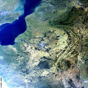
France - MERIS, 18 February 2003
It's a perfectly clear February day over France in this Medium Resolution Imaging Spectrometer (MERIS) image mosaic.
The enhanced true colour image clearly shows the varied landscapes of the country from the large urban expanse of the Paris conurbation, the snow capped regions of the Ardennes, Massif Central, Alps and the Pyrenees, the heavily vegetated lowland hills stretching down the east of the country, and the distinctive darker triangle of the Landes Region south of Bordeaux caused by extensive Pine forests.
Along the coasts of France, Belgium and the UK we see a change in the sea surface colour from a blue to a lighter green shade, this is caused by increased sedimentation particularly observed in the English Channel. We can also see sediment being pumped into the North Sea from the Thames estuary flowing out of London.
Technical Information:
Instrument: MEdium Resolution Imaging Spectrometer (MERIS)
Date of Acquisition: 18 February 2003
Orbit number: 05072
Instrument features: Full Resolution image (300 - metre resolution)