About ESA
The European Space Agency (ESA) is Europe’s gateway to space. Its mission is to shape the development of Europe’s space capability and ensure that investment in space continues to deliver benefits to the citizens of Europe and the world.
Highlights


Latest


Space in Member States
Find out more about space activities in our 23 Member States, and understand how ESA works together with their national agencies, institutions and organisations.
 Germany
 Austria
 Belgium
 Denmark
 Spain
Spain
 Estonia
 Finland
 France
 Greece
 Hungary
 Ireland
 Italy
Italy
 Luxembourg
 Norway
 The Netherlands
 Poland
 Portugal
 Czechia
 Romania
 United Kingdom
 Slovenia
 Sweden
 Switzerland
Science & Exploration
Exploring our Solar System and unlocking the secrets of the Universe
Go to topicAstronauts


Latest


Enabling & Support
Making space accessible and developing the technologies for the future
Go to topicLatest


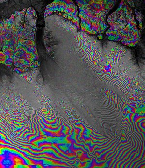
WSM/WSM InSAR over Dutch coast
Prof. Monti Guarnieri of Polimi identified a cooperative pair of SCANSAR images acquired over the Netherlands in December 2002 and January 2003. The Fringe pattern illustrates the good coherence obtained from the two acquisition separated by 35 days. The potential applications for SCANSAR/SCANSAR interferometry include DEM generation, ground movement mapping and atmospheric water vapour characterisation over unprecedentedly large areas.
The results jointly achieved by Prof. Monti Guarnieri, Politecnico di Milano, and the SAR processing team of Prof. Cafforio, Politecnico di Bari, clearly identify the applications potential of the new Envisat level-1 product in generating the first SCANSAR-SCANSAR interferogram generated over a 400x400km area. Unlike the Algeria SCANSAR-SCANSAR interferogram, which had been compensated by an available digital elevation model (DEM) this interferogram was only compensated for flat earth.