About ESA
The European Space Agency (ESA) is Europe’s gateway to space. Its mission is to shape the development of Europe’s space capability and ensure that investment in space continues to deliver benefits to the citizens of Europe and the world.
Highlights


Latest


Space in Member States
Find out more about space activities in our 23 Member States, and understand how ESA works together with their national agencies, institutions and organisations.
 Germany
 Austria
 Belgium
 Denmark
 Spain
Spain
 Estonia
 Finland
 France
 Greece
 Hungary
 Ireland
 Italy
Italy
 Luxembourg
 Norway
 The Netherlands
 Poland
 Portugal
 Czechia
 Romania
 United Kingdom
 Slovenia
 Sweden
 Switzerland
Science & Exploration
Exploring our Solar System and unlocking the secrets of the Universe
Go to topicAstronauts


Latest


Enabling & Support
Making space accessible and developing the technologies for the future
Go to topicLatest


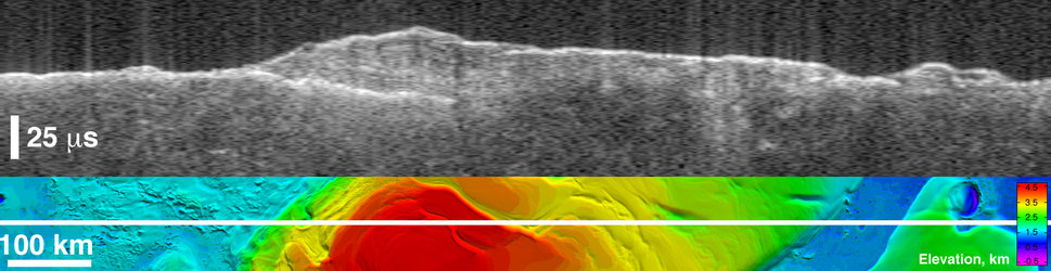
Other subsurface echoes from buried basins
Radargrams and ground-range projections of MARSIS data obtained in July 2005 when Mars Express was flying over the Chryse Planitia region of Mars. The two bottom images show the subsurface echoes projected on MOLA colour-coded shaded relief. Echoes are plotted in time-delay versus position along the orbit track. The peak surface return is corrected to agree with the MOLA topography.
The top left radargram was obtained thanks to MARSIS data on 9 July (orbit 1903), while the top right one was obtained thanks to data gathered on 6 July (orbit 1892). Parabolic echoes that project as arcs on the surface are interpreted to be from the near and far rim walls (relative to the orbit track) of buried impact basins.
The dashed white circles are approximate fits to the arcs (echoes labelled in the radargrams). Echoes are interpreted to be from the far rim wall of an approximately 220-km-diameter basin (corresponding echoes in a. and b. labelled as ‘Far wall’), superimposed on a larger, 310-km-diameter basin that may have echoes from the top and bottom of the near rim wall (corresponding echoes in a. and b. labelled as ‘Near wall’).

Subsurface echoes from buried basins

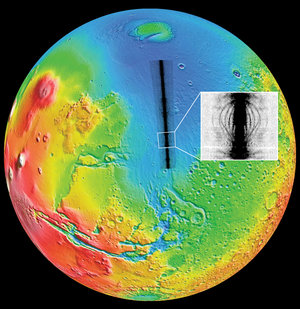
Location of buried basins detected by MARSIS
Subsurface echoes from Chryse Planitia plains

Radar echoes