About ESA
The European Space Agency (ESA) is Europe’s gateway to space. Its mission is to shape the development of Europe’s space capability and ensure that investment in space continues to deliver benefits to the citizens of Europe and the world.
Highlights


Latest


Space in Member States
Find out more about space activities in our 23 Member States, and understand how ESA works together with their national agencies, institutions and organisations.
 Germany
 Austria
 Belgium
 Denmark
 Spain
Spain
 Estonia
 Finland
 France
 Greece
 Hungary
 Ireland
 Italy
Italy
 Luxembourg
 Norway
 The Netherlands
 Poland
 Portugal
 Czechia
 Romania
 United Kingdom
 Slovenia
 Sweden
 Switzerland
Science & Exploration
Exploring our Solar System and unlocking the secrets of the Universe
Go to topicAstronauts


Latest


Enabling & Support
Making space accessible and developing the technologies for the future
Go to topicLatest


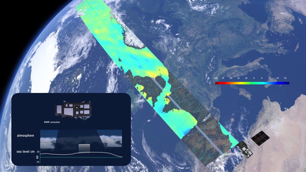
Lake Van water height from Sentinel-3B
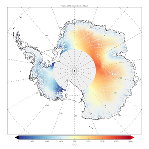
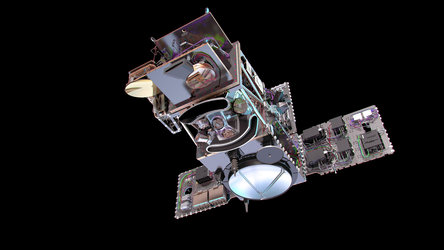
Launched on 25 April 2018, the Sentinel-3B satellite has already delivered impressive first images from its ocean and land colour instrument and from its radiometer. It has now also delivered data from its altimeter – which means that all of the instruments are working well.
The altimeter has measured the height of Lake Van in east Turkey, close to the boarder of Iran. This brackish lake is the largest body of water in Turkey. The image shows two tracks, about 7 km apart, across the lake: one from the Sentinel-3A satellite on 26 April 2018 and one from Sentinel-3B on 9 May. They measure the lake to be 1647 m above sea level and clearly show the transition from land to water.
Sentinel-3B will not be fully commissioned for service for another five months or so, but even at this early stage in its life in orbit, these data compare well with those of its fully-operational twin, Sentinel-3A. The altimeter is particularly important for measuring changes in sea level, but as this example shows, the instrument also contributes to monitoring the height of lake water through the Copernicus Global Land Service. It is also used to measure the height of ice.
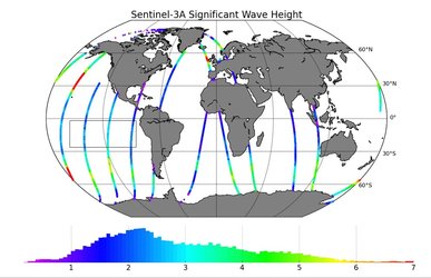
The Sentinel-3B satellite lifted off from Russia on 25 April and joins it identical twin, Sentinel-3A, in orbit. This pairing of satellites increases coverage and data delivery for the European Union’s Copernicus environment programme. Both Sentinel-3 satellites carry the same suite of instruments.
Eumetsat has also released new results from the Sentinel-3B altimeter.