About ESA
The European Space Agency (ESA) is Europe’s gateway to space. Its mission is to shape the development of Europe’s space capability and ensure that investment in space continues to deliver benefits to the citizens of Europe and the world.
Highlights


Latest


Space in Member States
Find out more about space activities in our 23 Member States, and understand how ESA works together with their national agencies, institutions and organisations.
 Germany
 Austria
 Belgium
 Denmark
 Spain
Spain
 Estonia
 Finland
 France
 Greece
 Hungary
 Ireland
 Italy
Italy
 Luxembourg
 Norway
 The Netherlands
 Poland
 Portugal
 Czechia
 Romania
 United Kingdom
 Slovenia
 Sweden
 Switzerland
Science & Exploration
Exploring our Solar System and unlocking the secrets of the Universe
Go to topicAstronauts


Latest


Enabling & Support
Making space accessible and developing the technologies for the future
Go to topicLatest


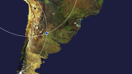
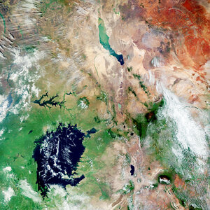
Lake Mar Chiquita, Argentina
The Copernicus Sentinel-1 mission takes us over Lake Mar Chiquita – an endorheic salt lake in the northeast province of Córdoba, Argentina.
Zoom in to see this image at its full resolution or click on the circles to learn more about the features in it.
Lake Mar Chiquita, around 70 km long and 24 km wide, is fed primarily by the Primero and Segundo rivers from the southwest and from the Dulce river from the north. While these rivers flow into the lake, there isn’t a natural outflow of water so it only loses water by evaporation, hence Lake Mar Chiquita being described as an endorheic lake. The lake’s surface area, as well as its salinity, varies considerably (ranging between 2000 and 6000 sq km), although it is slowly diminishing in size owing to evaporation.
Several small islands lie in the lake, the most important of which is El Médano. Vast expanses of saline marshes can be seen on the lake’s northern shore. The lake has been designated as a Ramsar Site of International Importance, and is considered one of the most important wetlands in Argentina owing to its rich biodiversity. Over 25 species of fish are known to breed in Lake Mar Chiquita, with fishing and livestock being the principal land uses.
The colours of this week’s image come from the combination of two polarisations from the Sentinel-1 radar mission, which have been converted into a single image.
As radar images provide data in a different way than a normal optical camera, the images are usually black and white when they are received. By using a technology that aligns the radar beams sent and received by the instrument in one orientation – either vertically or horizontally – the resulting data can be processed in a way that produces coloured images such as the one featured here. This technique allows scientists to better analyse Earth’s surface.
Shades of blue in the image show us where the differences between the two polarisations are higher, for example the saline marshes in the lake’s north, whereas the crops and agricultural fields in the surrounding area appear yellow, indicating fewer differences between polarisations. Fields, such as those visible in the bottom-left corner of the image, appear blue most likely because they are wetter. Several villages, including San Francisco and Rafaela, are identifiable in white in the bottom-right of the image.
This image, acquired on 17 November 2020, is also featured on the Earth from Space video programme.