Germany
 Austria
 Belgium
 Denmark
 Spain
Spain
 Estonia
 Finland
 France
 Greece
 Hungary
 Ireland
 Italy
Italy
 Luxembourg
 Norway
 The Netherlands
 Poland
 Portugal
 Czechia
 Romania
 United Kingdom
 Slovenia
 Sweden
 Switzerland


EarthCARE synergy reveals power of clouds and aerosols
With the initial images from each of the instruments aboard ESA’s EarthCARE satellite now in hand, it's time to reveal how these four advanced sensors work in synergy to measure exactly how clouds and aerosols influence the heating and cooling of our atmosphere.
Unveiled today at the International Astronautical Congress in Milan, Italy, these new results clearly highlight how EarthCARE's instruments can take different measurements of clouds and aerosols at the same time. These synergistic measurements promise to yield crucial insights into Earth’s delicate energy balance.
The energy balance accounts the amount of energy Earth receives from the Sun and the amount of thermal radiation it emits back out to space. Influenced by numerous factors, including clouds, aerosols and greenhouse gases, this balance is vital for regulating Earth’s climate.
While it is known that clouds and aerosols generally help cool the atmosphere, their interactions with incoming and outgoing heat are highly complex, and still not fully understood.


Access the video
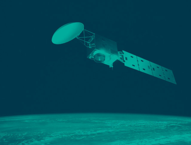
Launched in May 2024, EarthCARE – a mission realised through a joint venture between ESA and the Japan Aerospace Exploration Agency, JAXA – has the important task of measuring various aspects of our atmosphere to help us understand how clouds and aerosols reflect incoming solar energy back out to space and how they trap outgoing infrared energy.
ESA’s Director of Earth Observation Programmes, Simonetta Cheli, said, “Although we are still in the early stages of the mission and busy with the satellite’s commissioning phase, the results we present today are truly remarkable.
“Not only do they further confirm that all four instruments and the complex way the data are processed are functioning exceptionally well, but they also highlight the power of their combined measurements. This demonstrates that the mission is on track to achieve its objectives.
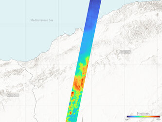
“The data, which were captured on 18 September, offer a sweeping view from Central Europe to Sweden. Notably, they reveal the many different signatures of a thunderstorm over northern Italy, near Milan where we are today.”

EarthCARE’s cloud profiling radar, which was provided by JAXA, shows information on the vertical structure and internal dynamics of clouds, the atmospheric lidar delivers profiles of aerosols and thin clouds as well as cloud-top information, the multispectral imager offers a wide-scene overview in multiple wavelengths, and the broadband radiometer measures reflected solar radiation and outgoing infrared radiation coming from Earth.
The animation above highlights two key features to demonstrate EarthCARE’s synergistic capabilities.
While the multispectral imager provides the overall context of the scene throughout, the animation first focuses on a recent thunderstorm over northern Italy and northern Corsica. The storm caused severe flooding in Italy’s Emilia Romagna region and was part of the larger convective system associated with Storm Boris, which devastated parts of Central Europe.
At this stage of the animation, the cloud profiling radar delivers most of the data owing to the large particles forming within the thunderclouds. Next, the atmospheric lidar detects a 1–2 km layer at the cloud's uppermost region, revealing crucial details about the ice layer at the cloud top.

The full synergy between the cloud profiling radar and lidar becomes evident when focusing near to the top of the cloud, where both instruments provide complementary data, allowing for more detailed cloud characterisation.
Ultimately, EarthCARE’s mission is to deliver insights on where clouds and aerosols are either warming or cooling the atmosphere, and these initial synergistic results demonstrate this effectively.
They reveal a strong cooling effect at the top of the thunderstorm due to the high emission of thermal radiation into space. Beneath this cooling layer, the dense cloud absorbs heat radiating from Earth’s surface, creating a warming effect.
Secondly, the animation highlights cirrus clouds over Sweden, which are part of a high-altitude ice-cloud formation. These clouds are particularly significant for climate science because, while they appear thin and allow sunlight to pass through thereby warming Earth's surface, they also trap thermal radiation emitted from Earth’s surface, preventing it from escaping into space. This dual effect contributes to an overall warming of the atmosphere.
In contrast to the thunderstorm, the atmospheric lidar provides information over nearly the entire cirrus cloud, between 8 and 13 km in altitude, while the radar primarily focuses on the lower region where larger ice crystals form. However, in the lower two kilometres, both the radar and lidar contribute data, enabling synergistic retrievals over a significant portion of the cirrus cloud.

The overall heating effect of cirrus clouds, particularly in their upper layers, is evident where the clouds absorb both solar radiation from above and, from below, thermal radiation emitted from the Earth’s surface. This warming effect is interrupted in areas where the cloud thickens and larger ice particles form, blocking the thermal radiation from the Earth.
In these denser regions, the cloud top cools by emitting thermal radiation into space. Despite these localised cooling effects, cirrus clouds contribute to the overall warming of the atmosphere.
Other features include a low-level aerosol layer, likely linked to pollution-related haze over Germany, and a low-altitude marine cloud over the southern Baltic Sea.
Thorsten Fehr, ESA’s EarthCARE Mission Scientist said, “Having the data available at this early stage is a testament to the outstanding work of the EarthCARE team, particularly the scientists who developed these data products. This highlights EarthCARE’s unique capability to simultaneously provide direct measurements of both clouds and aerosols, enabling an unprecedented assessment of their impact on climate.”
JAXA too has been busy processing synergist data, read: Synergistic cloud images by EarthCARE.
Hitonori Maejima, Senior Chief Officer on Earth Observation Missions at JAXA, said, “By combining measurements from its four sensors, EarthCARE can capture different types of cloud, aerosols and their function. This is a symbol of the collaboration between ESA and JAXA.”