About ESA
The European Space Agency (ESA) is Europe’s gateway to space. Its mission is to shape the development of Europe’s space capability and ensure that investment in space continues to deliver benefits to the citizens of Europe and the world.
Highlights


Latest


Space in Member States
Find out more about space activities in our 23 Member States, and understand how ESA works together with their national agencies, institutions and organisations.
 Germany
 Austria
 Belgium
 Denmark
 Spain
Spain
 Estonia
 Finland
 France
 Greece
 Hungary
 Ireland
 Italy
Italy
 Luxembourg
 Norway
 The Netherlands
 Poland
 Portugal
 Czechia
 Romania
 United Kingdom
 Slovenia
 Sweden
 Switzerland
Science & Exploration
Exploring our Solar System and unlocking the secrets of the Universe
Go to topicAstronauts


Latest


Enabling & Support
Making space accessible and developing the technologies for the future
Go to topicLatest


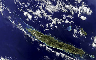
France, NewCaledonia - MERIS - 12 September 2003
The main island of the French territory of New Caledonia, Grande Terre, is visible in the lower part of this Meris image. The island is a long mountain range which reaches 1,639 meters in altitude. It is surrounded by a coral reef which varies in distance from the coast, as much as 65 kilometres in some spots, as little as two or three kilometres in others. The island is flanked to the northeast by the Loyalty islands. Ouvea, to the west, is an old-reef raised limestone island; Lifou and Mare, to the east, are uplifted coral atolls.
Much farther north, the New Hebrides archipelago, or Vanuatu group, can be seen. The islands of this Y-shaped chain are volcanic; several volcanoes are still active.
Technical Information:
Instrument: MEdium Resolution Imaging Spectrometer (MERIS)
Date of Acquisition: 12 September 2003
Orbit number: 08028
Instrument features: RR
Coordinates:
NE Lat/Long: S 14.04 / E 171.39
NW Lat/Long: S 11.75 / E 160.92
SW Lat/Long: S 24.32 / E 157.51
SE Lat/Long: S 26.68 / E 168.80