About ESA
The European Space Agency (ESA) is Europe’s gateway to space. Its mission is to shape the development of Europe’s space capability and ensure that investment in space continues to deliver benefits to the citizens of Europe and the world.
Highlights


Latest


Space in Member States
Find out more about space activities in our 23 Member States, and understand how ESA works together with their national agencies, institutions and organisations.
 Germany
 Austria
 Belgium
 Denmark
 Spain
Spain
 Estonia
 Finland
 France
 Greece
 Hungary
 Ireland
 Italy
Italy
 Luxembourg
 Norway
 The Netherlands
 Poland
 Portugal
 Czechia
 Romania
 United Kingdom
 Slovenia
 Sweden
 Switzerland
Science & Exploration
Exploring our Solar System and unlocking the secrets of the Universe
Go to topicAstronauts


Latest


Enabling & Support
Making space accessible and developing the technologies for the future
Go to topicLatest


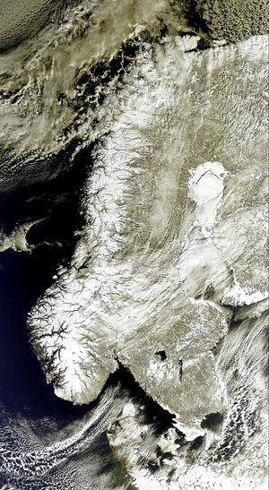
Cloud streets over Scandinavia
This Envisat image captures cloud streets – parallel rows of clouds that align with the wind – and the northern part of the Scandinavian Peninsula, the largest peninsula in Europe, shared by Norway (left and top), Sweden (left of the Gulf of Bothnia seen at bottom centre) and Finland (right of the gulf). The Russian Federation is visible along the right side of the image. Cloud streets (upper right corner) have formed over the Barents Sea due to the mixture of heat, moisture and wind. In this image, cold, dry air masses over the ice are flowing from the north to the south. This image was acquired by Envisat's Medium Resolution Imaging Spectrometer (MERIS) instrument on 5 April 2009, working in Full Resolution mode to provide a spatial resolution of 300 m.