About ESA
The European Space Agency (ESA) is Europe’s gateway to space. Its mission is to shape the development of Europe’s space capability and ensure that investment in space continues to deliver benefits to the citizens of Europe and the world.
Highlights


Latest


Space in Member States
Find out more about space activities in our 23 Member States, and understand how ESA works together with their national agencies, institutions and organisations.
 Germany
 Austria
 Belgium
 Denmark
 Spain
Spain
 Estonia
 Finland
 France
 Greece
 Hungary
 Ireland
 Italy
Italy
 Luxembourg
 Norway
 The Netherlands
 Poland
 Portugal
 Czechia
 Romania
 United Kingdom
 Slovenia
 Sweden
 Switzerland
Science & Exploration
Exploring our Solar System and unlocking the secrets of the Universe
Go to topicAstronauts


Latest


Enabling & Support
Making space accessible and developing the technologies for the future
Go to topicLatest


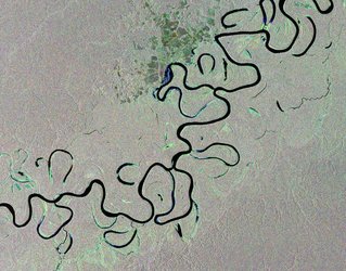
Boca do Acre, Brazil
This Envisat radar image was acquired over the city of Boca do Acre in western Brazil.
The city lies within Amazonas state, the largest Brazilian state by area, and almost completely covered by the Amazon Rainforest.
The name Boca do Acre – or ‘mouth of the Acre’ – comes from its location on the banks where the Acre and Purus rivers meet.
Along the river’s main course are free-standing ‘oxbow lakes’, formed when a river changes course.
This scene is a compilation of three images from Envisat’s radar, acquired on 28 October 2005, 12 September 2008 and 17 September 2010. The individual images are each assigned a colour – red, green and blue – and when combined, reveal changes in the surface between Envisat’s passes.
In this image, the colours reveal large areas of deforestation – evident by the large, geometrically shaped plots cut out along linear roads.
Given its size and frequent cloud cover, remote sensing using radar images is the best way to study the Amazon Basin on a large scale, especially for assessing the extent and damage due to deforestation. Radars can observe during both day and night and through any weather conditions.
Satellite observations also support the United Nations’ Reducing Emissions from Deforestation and Forest Degradation in developing countries, or REDD, initiative.
Trees absorb carbon dioxide and convert it into oxygen, while trees that rot, are cut down or burnt actually emit carbon dioxide. So preserving forests not only keeps them from releasing the gas, it ensures the absorption of carbon dioxide from other sources.
REDD gives a financial incentive for developing countries to maintain forested areas. Reducing or preventing deforestation is the mitigation option with the largest and most immediate carbon stock impact in the short term, as the release of carbon as emissions into the atmosphere is prevented.
Upcoming missions such as Sentinel-1 and -2, being developed for Europe’s Copernicus programme, as well as ESA’s Biomass satellite, will support REDD in forest mapping and monitoring.
This image is featured on the Earth from Space video programme.