About ESA
The European Space Agency (ESA) is Europe’s gateway to space. Its mission is to shape the development of Europe’s space capability and ensure that investment in space continues to deliver benefits to the citizens of Europe and the world.
Highlights


Latest


Space in Member States
Find out more about space activities in our 23 Member States, and understand how ESA works together with their national agencies, institutions and organisations.
 Germany
 Austria
 Belgium
 Denmark
 Spain
Spain
 Estonia
 Finland
 France
 Greece
 Hungary
 Ireland
 Italy
Italy
 Luxembourg
 Norway
 The Netherlands
 Poland
 Portugal
 Czechia
 Romania
 United Kingdom
 Slovenia
 Sweden
 Switzerland
Science & Exploration
Exploring our Solar System and unlocking the secrets of the Universe
Go to topicAstronauts


Latest


Enabling & Support
Making space accessible and developing the technologies for the future
Go to topicLatest


The Living Planet VNR

Embargoed until 06/07/99 - when the Living Planet programme will be launched, in London - this VNR summarises ESA's new Living Planet programme of Earth Observation. The aim of this programme is to build upon the success of previous programmes - such as Metesoat and ERS - with two new types of mission, named Earth Explorer and Earth Watch.
The VNR contains graphics to illustrate these missions, as well as contemporary and historical footage describing ESA's involvement in the global Earth Observation market.
Living Planet Shotlist
10 :00 :12 :00 conditions of use/opening titles
10 :01 :01 :00 contents page
10 :01 :10 :00 A-roll
10 :03 :27 :00 Caption : B-roll, Mission Graphics
10 :03 :36 :00 Graphics of a proposed Earth Explorer mission: GOCE (Global Ocean Circulation Experiment) scans the Earth
10 :03 :41 :00 GOCE readings on globe
10 :03 :51 :00 GOCE scans the Earth [with wobble of its orbit shown due to the gravity field variations]
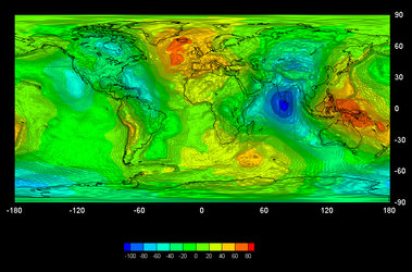
10 :04 :01 :00 'Potato Earth' exaggerated representation of gravimetric data from ESA's ERS-1 satellite
10 :04 :20 :00 Earth Watch graphics : proposed Euroskymed satellite constellation in orbit
10 :04 :32 :00 Euroskymed satellite's eye view of Earth, with zi and tracking to find simulated interferogram of volcano
10 :05 :12 :00 Simulated satellite image of forest fires
10 :05 :34 :00 Simulated satellite image of agricultural shrinkage
10 :05 :57 :00 Caption : Hurricane Mitch Graphics
10 :06 :02 :00 sequence : zi to central America [Honduras and Nicaragua], sate