About ESA
The European Space Agency (ESA) is Europe’s gateway to space. Its mission is to shape the development of Europe’s space capability and ensure that investment in space continues to deliver benefits to the citizens of Europe and the world.
Highlights


Latest


Space in Member States
Find out more about space activities in our 23 Member States, and understand how ESA works together with their national agencies, institutions and organisations.
 Germany
 Austria
 Belgium
 Denmark
 Spain
Spain
 Estonia
 Finland
 France
 Greece
 Hungary
 Ireland
 Italy
Italy
 Luxembourg
 Norway
 The Netherlands
 Poland
 Portugal
 Czechia
 Romania
 United Kingdom
 Slovenia
 Sweden
 Switzerland
Science & Exploration
Exploring our Solar System and unlocking the secrets of the Universe
Go to topicAstronauts


Latest


Enabling & Support
Making space accessible and developing the technologies for the future
Go to topicLatest


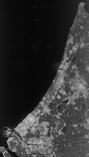
Amsterdam, Netherlands
The Copernicus Sentinel-2B satellite takes us over part of the western Netherlands on 16 March, with the capital city of Amsterdam at the centre of the image.
Divided among some 90 islands, Amsterdam has more than 100 km of canals. The city lies about 2 m below sea level – in fact, around a third of the country lies below sea level, making it susceptible to floods. Rising sea waters during periods of bad weather – called storm surges – are kept under control by dams, dikes, floodgates and natural sand dunes.
While we can see the North Sea on the left, the water on the right is part of the Markermeer lake. This area was once a saltwater bay called the Zuiderzee, but was closed off by a dam in the 1930s. The bay was drained in stages and land reclaimed, including Flevoland on the right side of the image – one of the world’s largest artificial islands.
Another relatively recent addition to the Dutch landscape is the neighbourhood of IJburg comprising six artificial islands east of Amsterdam. The first residents moved in only 15 years ago.
Satellites like Sentinel-2 can help to monitor urban expansion. For example, in the upper-right corner we see what looks like an artificial island being built – but this structure is not present in satellite imagery from a year ago.
The meticulously planned landscape seen in most of the image breaks for the coastal dunes along the left. These areas are home to dozens of bird species, as well as deer, squirrels, rabbits and foxes. In one protected area, grazing animals including Highland cattle were introduced to the area.
This image is featured on the Earth from Space video programme.