About ESA
The European Space Agency (ESA) is Europe’s gateway to space. Its mission is to shape the development of Europe’s space capability and ensure that investment in space continues to deliver benefits to the citizens of Europe and the world.
Highlights


Latest


Space in Member States
Find out more about space activities in our 23 Member States, and understand how ESA works together with their national agencies, institutions and organisations.
 Germany
 Austria
 Belgium
 Denmark
 Spain
Spain
 Estonia
 Finland
 France
 Greece
 Hungary
 Ireland
 Italy
Italy
 Luxembourg
 Norway
 The Netherlands
 Poland
 Portugal
 Czechia
 Romania
 United Kingdom
 Slovenia
 Sweden
 Switzerland
Science & Exploration
Exploring our Solar System and unlocking the secrets of the Universe
Go to topicAstronauts


Latest


Enabling & Support
Making space accessible and developing the technologies for the future
Go to topicLatest


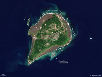
Earth from Space: Nishinoshima island, Japan
This Copernicus Sentinel-2 image features the Japanese island of Nishinoshima, in the northwest Pacific Ocean.
Zoom in to explore this image at its full 10 m resolution or click on the circles to learn more.
One of the Ogasawara Islands, Nishinoshima is a small uninhabited volcanic island roughly 1000 km south of Tokyo. Volcanic activity along the western edge of the Pacific Ring of Fire gave rise to this island, which is in fact the tip of a submerged volcano.
Until 1974, only a part of the ridge of the otherwise submerged caldera was visible, and the island was about 700 m long and 200 m wide. Since then, Nishinoshima has experienced alternating periods of explosive activity and calm, but lava from various eruptions over the years has led to the island growing bigger.
This image was acquired in January 2021 and here the island is around 2.3 km in the north-south direction and 2 km in the east-west direction.
The yellowish discolouration of the water around the island is due to volcanic minerals, gas and seafloor sediment that is being stirred up by the volcanic activity. It stretches for about 10 km to the southeast, where ocean currents turn it into bright green swirls.
A plume of gas and steam can be seen rising from the volcano and drifting northeast over the Pacific Ocean. As the plume rises higher, the steam condenses and forms clouds.
Volcanic plumes are of particular concern to the airline industry because ash can contaminate oxygen supplies and damage jet engines. Atmospheric sensors on satellites can identify the gases and aerosols released by eruptions, quantify their wider environmental impact and can help provide early warnings to the aviation industry.
Satellite data can also be used to better understand volcanic activity. Optical and radar instruments can image lava flows, mudslides, ground fissures and earthquakes, and be used to assess damage.