About ESA
The European Space Agency (ESA) is Europe’s gateway to space. Its mission is to shape the development of Europe’s space capability and ensure that investment in space continues to deliver benefits to the citizens of Europe and the world.
Highlights


Latest


Space in Member States
Find out more about space activities in our 23 Member States, and understand how ESA works together with their national agencies, institutions and organisations.
 Germany
 Austria
 Belgium
 Denmark
 Spain
Spain
 Estonia
 Finland
 France
 Greece
 Hungary
 Ireland
 Italy
Italy
 Luxembourg
 Norway
 The Netherlands
 Poland
 Portugal
 Czechia
 Romania
 United Kingdom
 Slovenia
 Sweden
 Switzerland
Science & Exploration
Exploring our Solar System and unlocking the secrets of the Universe
Go to topicAstronauts


Latest


Enabling & Support
Making space accessible and developing the technologies for the future
Go to topicLatest


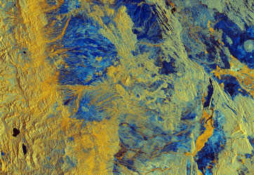
Earth from Space: Central Ethiopia
The Copernicus Sentinel-1 mission brings us a false-colour radar image of central Ethiopia.
Zoom in to explore this image at its full resolution or click on the circles to learn more.
The depicted area spans 600 km in length and 500 km in width, covering a significant portion of central Ethiopia. It includes multiple Sentinel-1 images from spring, summer and autumn 2023, which have been overlaid to create this single image.
Radar images capture surface texture rather than reflected light so they are naturally black and white but here images from each season have been assigned a different colour: red, green and blue respectively. When the images are combined, the different colours reveal variations that occurred in the different seasons.
Built-up areas and constructions are easy to identify as they usually appear as bright patches. Ethiopia’s capital, Addis Ababa, visible in the top right, stands out as does the black outline of the international airport to the south of the city.
Ethiopia’s terrain is one of the most rugged in Africa. South from Addis Ababa, the Main Ethiopian Rift traverses the middle of the image, featuring chain of volcanoes, faults and Ethiopia’s Lakes Region. The valley holds many small rivers that drain into several lakes, with the largest captured in the image being Lake Abaya. These lakes cover more than 3108 sq km.
While radar is particularly useful for picking out relief, water bodies show up dark because flat water surfaces reflect the radar signal away from the satellite. The various colours visible in some lakes are due either to the changing surface currents and sediments from rivers or to variations in water level.
At the bottom of the image, Lake Turkana (left) and Lake Chew Bahir (right) show different shades of colours because of alternating water levels. Different colours can also be seen along the Omo River delta, which enters Lake Turkana from the north. The basin, which results from the Gilgel Gibe III Dam blocking the river water flow, can be seen as a black feature resembling a lizard in the centre of the image.