Coastal change Danube Delta change detectionOil spillsDeforestation Bardia National ParkCongo River BasinKameng-Sonitpur Elephant ReserveKilimanjaroRondoniaShillong and GuwahatiIce Antarctica 2003Climate change and glaciersGlacier analysis using radar imageryGlacial retreat in the AlpsGlacier Ice FlowMonitoring of glaciers in the HimalayasRemote sensing of ice and snowUrbanisation CairoCity of KathmanduCórdobaHimalayasKathmandu ValleyLagosVegetation Annapurna Conservation AreaLost in the AndesNgorongoro Conservation AreaNiger Inland DeltaVegetation in South America
|  | | | | | | | Article Images |  |
Background
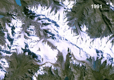
| Landsat satellite images showing retreating glaciers in the Andes of Peru, South America. (See GoogleEarth file location 3.8)
Credits: Landsat | |  |  | |
| | | | | | Model of a glacier with accumulation area, ablation area, terminal lake and moraine. To learn more about the dynamics of glaciers, go to our Glacier Ice Flow case study. | | | | |
| | | | | | | | | |
| | Climate change and glaciers IntroductionExercises Worksheet introductionExercise 1: Inspection of true colour RGB compositesExercise 2: AnimationExercise 3: Band ArithmeticExercise 4: GISExercise 5: Measurement of areaExercise 6: Multitemporal analysisConclusionsEduspace - Software LEOWorks 4 (MacOS)LEOWorks 4 (Linux)LEOWorks 4 (Windows)Eduspace - Download Andes_images.zipGoogleEarth file
|


 in the very east of the Berne canton in")
 in Switzerland")