ESA
Education
Home
Weather and Climate
Global Change
Natural Disasters
Coastal change
Danube Delta change detection
Oil spills
Deforestation
Bardia National Park
Congo River Basin
Kameng-Sonitpur Elephant Reserve
Kilimanjaro
Rondonia
Shillong and Guwahati
Ice
Antarctica 2003
Climate change and glaciers
Glacier analysis using radar imagery
Glacial retreat in the Alps
Glacier Ice Flow
Monitoring of glaciers in the Himalayas
Remote sensing of ice and snow
Urbanisation
Cairo
City of Kathmandu
Córdoba
Himalayas
Kathmandu Valley
Lagos
Vegetation
Annapurna Conservation Area
Lost in the Andes
Ngorongoro Conservation Area
Niger Inland Delta
Vegetation in South America
Search
Article Images
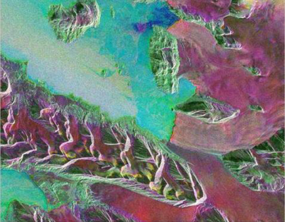
Exercise 1: Multitemporal radar and multispectral optical data
Back to article
Download:
HI-RES JPEG
(Size:
158 kb
)
Red indicates that the 29 Feb image (Red) is brightest in this combination, green indicates that the 13 June image (Green) is brightest, blue that the 26 Sept image (Blue) is brightest.
Credits: ESA
Glacier analysis using radar imagery
Introduction
Background
Radar
Synthetic Aperture Radar (SAR)
Exercises
Worksheet introduction
Exercise 2: The influence of weather conditions on radar imagery
Conclusions
Eduspace - Software
LEOWorks 4 (MacOS)
LEOWorks 4 (Windows)
LEOWorks 4 (Linux)
Eduspace - Download
Images_Glaciers.zip
GoogleEarth file
Copyright 2000 - 2015 © European Space Agency. All rights reserved.