ESAEducationHomeWeather and ClimateGlobal ChangeNatural Disasters
    24-Apr-2025
Coastal change
Danube Delta change detectionOil spills
Deforestation
Bardia National ParkCongo River BasinKameng-Sonitpur Elephant ReserveKilimanjaroRondoniaShillong and Guwahati
Ice
Antarctica 2003Climate change and glaciersGlacier analysis using radar imageryGlacial retreat in the AlpsGlacier Ice FlowMonitoring of glaciers in the HimalayasRemote sensing of ice and snow
Urbanisation
CairoCity of KathmanduCórdobaHimalayasKathmandu ValleyLagos
Vegetation
Annapurna Conservation AreaLost in the AndesNgorongoro Conservation AreaNiger Inland DeltaVegetation in South America


printer friendly page
Landslide detection in Langtang Himal - Part 2
 
This exercise is divided into two parts and requires the use of LEOWorks.
 
At the centre of the images you should be able to identify a landslide. If you have difficulty finding it, look at the figure for identification help.  
 
Landslide
 
1. Guess what area this landslide covers.


A landslide can usually be divided into 3 parts:
  • Landslide erosion: the place where land cover erodes.
  • Transportation: the area between the erosion and accumulation area.
  • Accumulation: at the end of the transportation zone, the landslide deposits its material.


Landslide zones
 
In the following part of the exercise you will measure these three parts of the landslide using the false colour infrared image.
Go to Image>Measure tool and a new window will open.
Click Units>Meters.
Carefully digitise, with the crosshair, the boundary of the landslide erosion zone. Click on your right mouse button once you are finished.
 
 
Measurement tool
 
Find out what is written in your measurement toolbox next to the field: Area!
It is the area of the landslide in square metres.
Do the same for the transportation zone, and measure the distance between the erosion and accumulation zone.
As a last step, measure the area of the accumulation zone.

1. Compare the measured area with your guesses.

2. Can you imagine an area of that size?

3. How many football fields would fit into an area of that size? The international standard for a football field is 68 x 105 m.


Previous


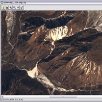
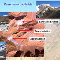
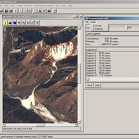
Himalayas
Environmental problems in the HimalayasUrbanisationThe Himalayan regionMountain ecosystemsNepal areaTibet area
Exercises
Himalaya - WorksheetLandscape units of NepalUrbanisation – 40 years of urban development of LhasaUrbanisation – Detection by means of delineation of the city perimeterLandslide detection in Langtang Himal
Links
Further Reading
Eduspace - Software
LEOWorks 3
Eduspace - Download
Himalayas_env1.zipHimalayas_env2.zipHimalayas_env3.zipHimalayas_env4.zip
Eduspace - Download
MERIS images of Kathmandu valley (zip file)
Eduspace - Software
LEOWorks 3ArcExplorer


   Copyright 2000 - 2014 © European Space Agency. All rights reserved.